The next major phase in Sheffield City Council’s plans to regenerate the historic area of Castlegate is underway as essential geoarchaeological work begins.
Geoarchaeological investigations will be carried out by archaeology and heritage specialists, Wessex Archaeology, as they conduct 33 borehole surveys across the site of Sheffield Castle to examine the characteristics and conditions of the site’s underlying groundworks. The findings will then be analysed to give insights into what is underground and in turn inform the council’s redevelopment proposals for the area.
It marks a significant step in propelling the council’s plans to revitalise Castlegate after securing £20m from the government’s Levelling Up Fund last year.
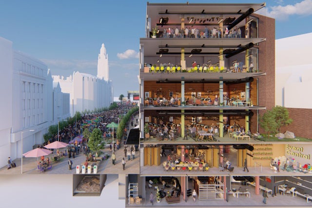
Plans include the de-culverting of the River Sheaf, interpretation of the castle remains and the creation of attractive green public spaces; the creation of a cultural destination providing S1 Artspace and Sheffield Music Academy and Sheffield Music Hub with new state-of-the-art facilities; the preparation of land for future uses and investment; better connectivity and improved infrastructure for active travel.
In consultation with South Yorkshire Archaeology and Historic England, each borehole’s location has been carefully planned based on a need to further investigate the site, in order to add the information to the previously conducted archaeological evaluations, including the one carried out by Wessex Archaeology in 2018, after the Castle Markets were demolished.
This phase will supplement the information gathered from earlier assessments to produce a report, a detailed deposit model and archaeological sensitivity map to feed into a constraints plan for the area. The drilling is expected to last 6 weeks.
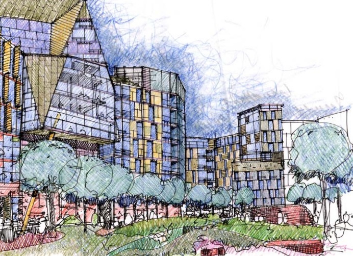
Castle Market Site. Illustration of the proposed mixed use development and open space from Sheffield City Council.
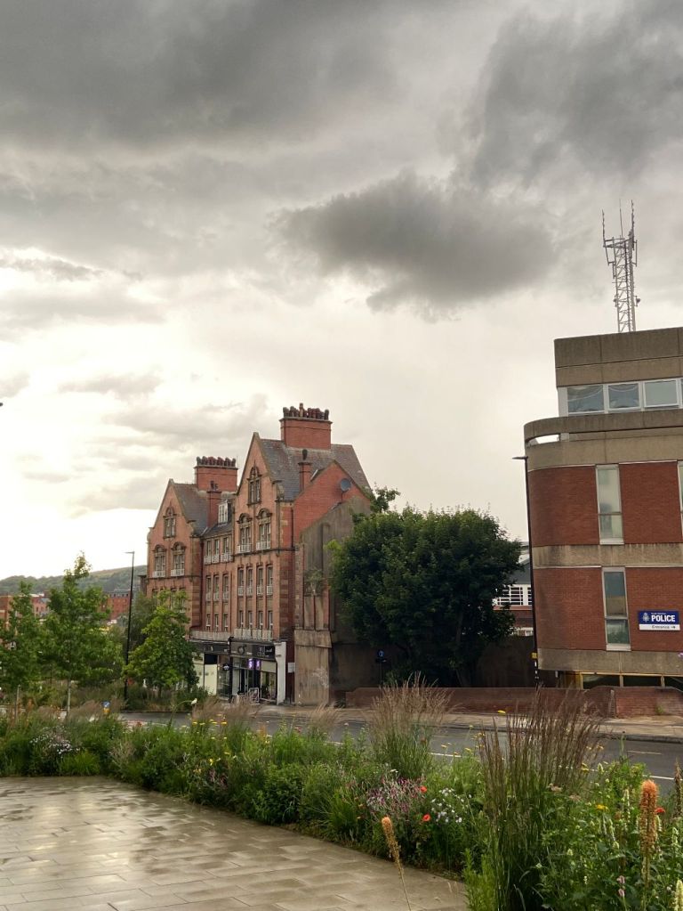
Snig Hill, looking down towards Bridge Street. Snig Hill Police Station can be seen on the right. Image: DJP/2022
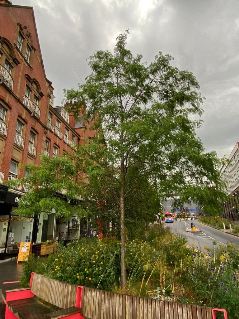
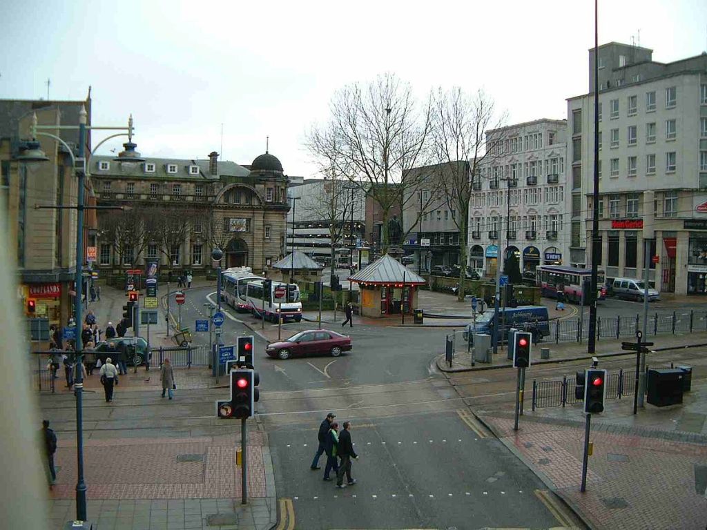
Mention Snig Hill and most people will attach the name to the police station that has stood here since 1970. But Snig Hill refers to the sloping road between the bottom of Angel Street and West Bar. This was once a bustling thoroughfare but has been slowly downgraded because of traffic flow changes.
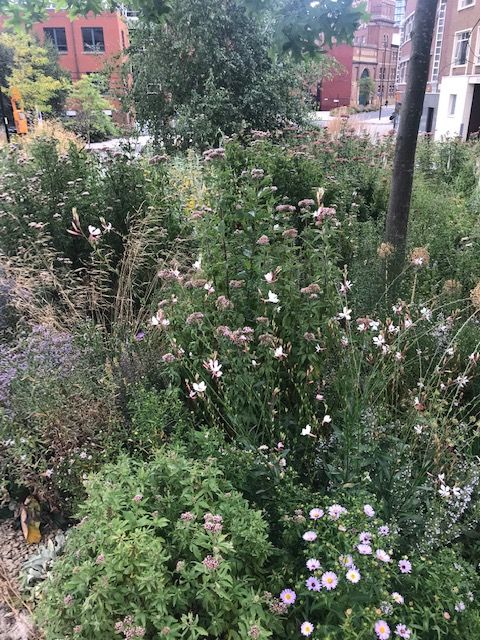
It is not an unpleasant place. The ‘grey-to-green’ project has seen the introduction of trees and wildflowers to re-connect the Castlegate area with the rest of the city centre and re-use redundant highway. And it soaks up rainwater that would have flowed into the nearby River Don, therefore reducing the risk of flooding.
The mystery about Snig Hill is how it got its name. It has mystified Sheffielders for centuries and various suggestions have been put forward.
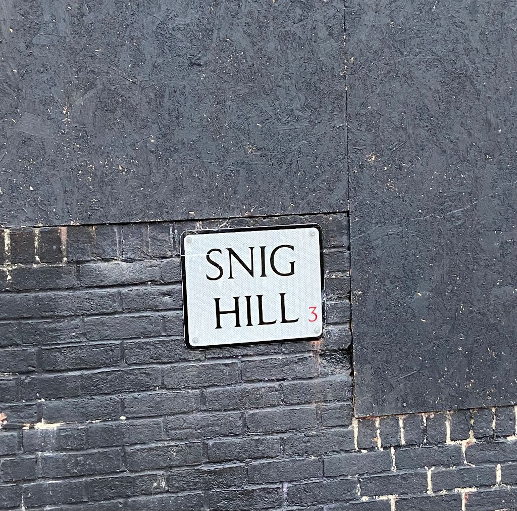
Snig Hill, street sign. Image: DJP/2022
Once upon a time, there was a corn mill at Millsands, next to the River Don, and to access this, people used a packhorse track running between high banks behind gardens of old houses that stood on what is now the right hand side of Snig Hill going down the hill.
According to J.W. Farnsworth in 1939, this became so waterlogged in wet weather with rain and the sewage that drained from the Beast Market, that it earned itself the name of Water Lane (think, Hen & Chickens, now Castle Green).
When Snig Hill was made and cobbled, the ancient lane fell into disuse, and several townsmen built houses. On the opposite side, at what became the Black Swan Hotel, was Costnough Hall which stood just below the Irish Cross at the junction of Angel Street.
The hall disappeared, and Snig Hill became a narrow street, and the projecting upper stories of the houses gave an appearance of still greater narrowness.
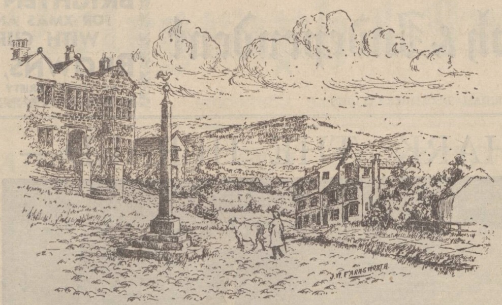
J.W. Farnsworth’s sketch of old Snig Hill. Costnough Hall is seen on the left. Image: British Newspaper Archive
And so, to the name. In dialect English, of the word ‘snig’ there were five meanings: (1) To cut or chop; (2) to sneak off; (3) to drag over the ground; (4) close and private; (5) a small eel.
One suggestion was that ‘Snig Hill’ derived its name from the fact that it was the incline up which the ‘trees’ were ‘snigged’ from the lower area (the area down to the banks of the river, say) which no doubt was very well wooded at one time.
A ‘snig chain’ was also the chain used for hauling timber or attaching an extra horse to a wagon. At our Snig Hill, it was said that a horse was once kept to ‘snig’ up the hill any wagon that paid a small fee.
But Sidney Oldall Addy in ‘A Glossary of Words used in Sheffield,’ published in 1888, thought differently.
“To snig a load of anything up a hill is to take up the load in two or more instalments. For instance, a load of timber might be left at the bottom of the hill. Each portion brought up would be called a snig. The incline of the hill is not great, and the hill is small. Snig Hill thus appears to mean Little Hill. I think this is really the meaning, there being no proof that the timber was ever dragged up the hill in instalments.”
But he contradicted himself in ‘The Hall of Waltheof,’ published in 1893.
“The word snug, meaning lying close and warm is identical with the word snig used in this street name. It is not the hill in this case, which is snug, but the narrow old street, and had it been Snicket Hill, the meaning would have been clear.”
Others thought that it took its name from the practice of putting a ‘snig’ or length of wood through the back wheels of carts going down the hill to act as a brake.
Snig Hill, looking towards Angel Street. Image: DJP/2022
Willis Crookes, of Normandale, Loxley, said in 1930 that at the Bridge Street end of Snig Hill, there was a depression in the road, where a pool once existed, and which was really a backwash of the River Don. He told of his boyhood (the 1870s), when he often talked to old men who told him that in their young days it swarmed with eels.
When anybody wanted a fish dinner they took a long stick with a cleft in it, pushed it into the mud of the pool, and dragged out an eel. This useful form of diversion was called ‘snigging.’
A far more likely explanation came about the same time from somebody who said that an old relative had been a stagecoach driver between Leeds and Sheffield. Among stories passed down in his family was one to the effect that the flour ground at Millsands was put into barrels and were ‘snigged up t’hill.’ He suggested that ‘to snig’ was to roll the barrel up the slope and put a under it.
However, it seems that the true meaning of ‘Snig Hill’ may never be known.
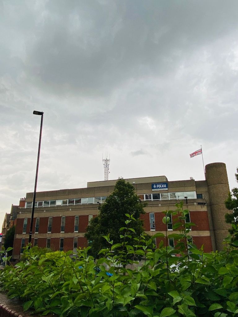
South Yorkshire Police at Snig Hill. It was originally built by B. Warren, Sheffield’s Planning Officer and Architect, as force headquarters for Sheffield and Rotherham Constabulary in 1970. It is now the police station covering Sheffield city centre. Image: DJP/2022
We’ve waited long enough to hear good news about Castlegate, and more importantly the site of old Sheffield Castle.
Sheffield has been successful in its bid to secure £20m of funding for Castlegate through the Government Levelling Up fund.
£15m of this will go towards further archaeological investigation and interpretation of the historic Castle remains for the public to view, quality open space, de-culverting of the River Sheaf and route-ways through the site. Targeted plots on the outer edges of the site will be made ‘developer ready’.
The remaining funding will go towards two other projects – Park Hill Art Space and Harmony Works.
Park Hill Art Space will deliver an arts, cultural and heritage destination at the Park Hill estate and it will aim to be one of the largest contemporary art galleries in the North, complemented by creative workspace and learning facilities, within a six-acre sculpture park.
Harmony Works is a partnership between Sheffield Music Academy and Sheffield Music Hub to create a new fit-for-purpose music academy by refurbishing Grade II listed Canada House on Commercial Street.
Looking up Fargate. An artist impression of the future.
Sheffield is one of 15 towns and cities to receive all the money they had bid for, in the Government’s Future High Streets Fund.
Sheffield will receive £15.8m in recognition of the ‘forward-thinking and innovative’ proposals to help progress plans to boost its reputation as an ‘Outdoor City’ with high quality public spaces for the community.
The historic streets of Fargate and High Street will become a high quality place to live, work, and socialise, in plans drawn up by Sheffield City Council and the University of Sheffield.
A radical programme of improvements and modern digital infrastructure will complement well-designed residential and workspace conversions, making the most of unused floorspace. Particular blocks will be redeveloped to increase density by adding height while opening up new green spaces and views.
This transformation will play a major role in completing plans for a ‘Steel Route’ through the city centre, turning a declining shopping area into a mixed-use link between the two distinct regeneration projects already underway in Heart of the City at one end and Castlegate at the other.
The funding has been awarded as part of the Government’s flagship £831 million Future High Streets Fund and will help areas to recover from the pandemic while also driving long term growth.
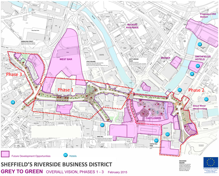
The recent post about Castlegate failed to mention that it is in the process of being part-pedestrianised, Phase 2 of Sheffield’s ‘Grey to Green’ project. Unless you visit this forgotten part of the city centre the relevance of the initiative might escape you.
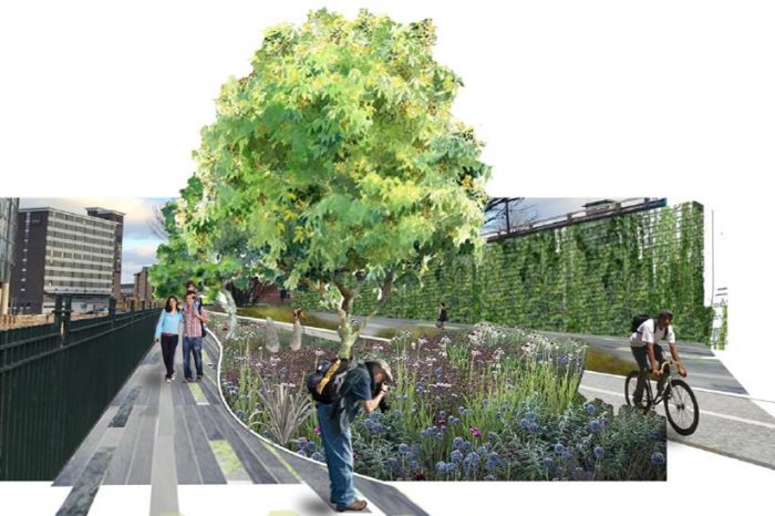
It is part of an approach to transform ‘redundant’ road space into a network of public spaces, sustainable drainage and urban rain gardens, which aims to improve the setting of the Riverside Business District, Castlegate and the rest of the city centre and then on to Kelham Island and Victoria Quays, as a place to work, live and enjoy, whilst also dealing with the effects of climate change.
Phase 1 (West Bar/Bridge Street/Snig Hill) was completed in Spring 2016 and was funded by the European Regional Development Fund, Sheffield City Region Infrastructure Fund and Sheffield City Council.
The area suffered catastrophic river floods in 2007. With the completion of the Inner Relief Road in 2008, traffic was diverted away from West Bar. The opportunity was seized to replace the ‘grey’ impermeable ‘redundant’ roads into ‘green’ permeable beds, transforming the space with colourful meadow-like planting and significantly increasing surface water storage.
With advice on plant selection from the University of Sheffield Landscape Department this has created a new townscape that is different to anything done in Sheffield before. Over 40,000 bulbs, 40 new trees, 600 evergreen shrubs and 26,000 herbaceous plants were introduced to form a seasonal urban meadow.
The new road layout was designed to slow vehicle speeds and make walking and cycling more attractive. New paving, street furniture, colourful seating and five eye-catching public art ‘totems’ celebrate the local history of the West Bar area including its Victorian music halls and theatres, its lively street life, its complex relationship to the river and its legacy of industry and brewing.
Phase 2 (Castlegate to Exchange Place) is nearing completion, and Phase 3 (Gibraltar Street to Shalesmoor) will eventually transform 1.2km of ‘redundant’ road-space into an attractive new linear green public space.
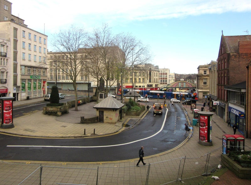
The name suggests that this is one of Sheffield’s ancient roads, perhaps named after Sheffield Castle, this stronghold destroyed by Parliamentarians during the 1600s. Castlegate is the road that runs alongside the River Don between Blonk Street and the junction of Waingate and Bridge Street.
However, you might be surprised to know that Castlegate is a relatively modern road and celebrates its centenary in 2030.
The road is found on the site of the lost castle and was first suggested by Edward Mitchel Gibbs, the Sheffield architect, as part of his ambitious plans for a Viaduct Scheme connecting Great Central Station (Victoria Station) with Haymarket.
The River Don Road was the only portion of the proposal adopted by Sheffield Corporation and built to ease congestion around Blonk Street, The Wicker and Lady’s Bridge. Its construction was made easier by the council’s Castle Hill Market development built on the embankment of the castle.
Castlegate (or Castle Gate), 60 feet wide and 200 yards long, was built at a cost of £13,000 in 1930, using over 9,000 tons of material, with a one-foot layer of strong concrete laid below the asphalt.
It was divided from the River Don by an old stone wall which had to be reinforced by 14 concrete buttresses each weighing 50 tons. Over the buttresses was a solid mass of concrete stretching from the wall halfway under the road and taking the weight of the traffic.
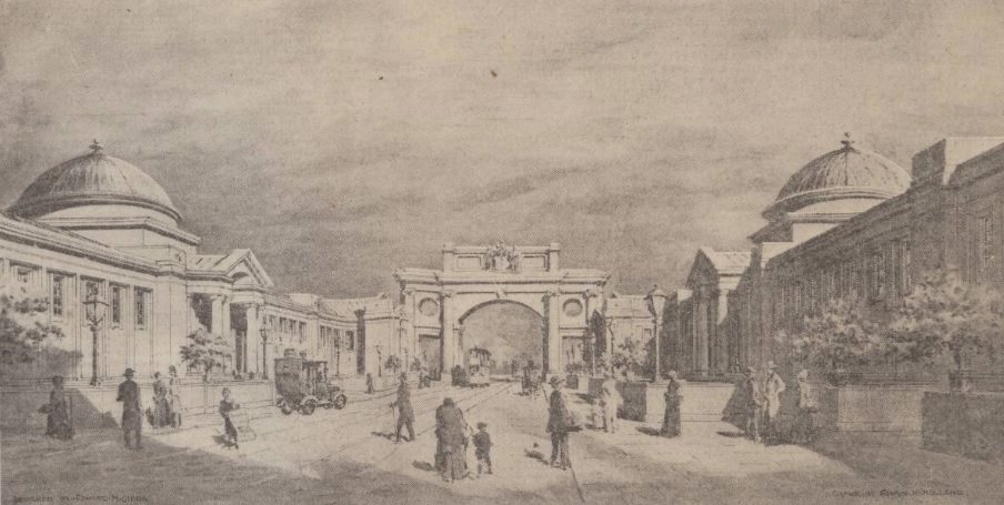
Markets on a grand scale. The proposed retail markets sketched by Alwyn Holland for E.M. Gibbs. (Image: The British Newspaper Archive)
The former Castle Market site lays in transition waiting for the day when a park is created between Castlegate and Exchange Street.
It was demolished in 2015 allowing the few remains of Sheffield Castle to be excavated in detail.
The area might be run-down and demands attention, but had an extravagant scheme been completed over a century ago, the place might look vastly different now.
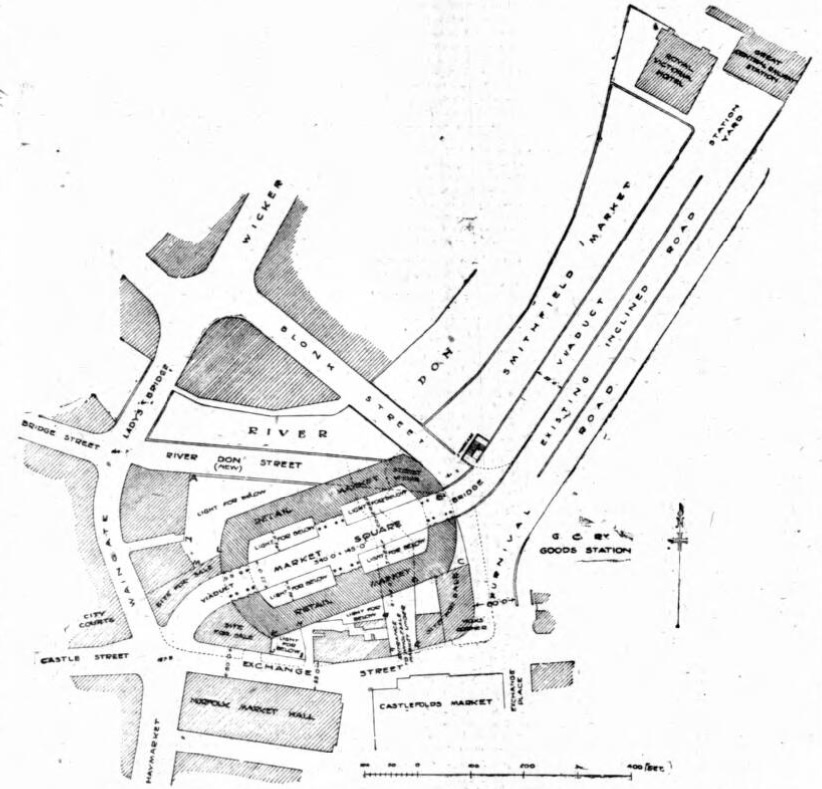
In 1911, Sheffield Corporation drew up plans to create a new street running from Great Central Station (Victoria Station) into the centre of the city. Objections were made by the Markets Committee that any such road would have made it impossible to complete its proposed new market scheme.
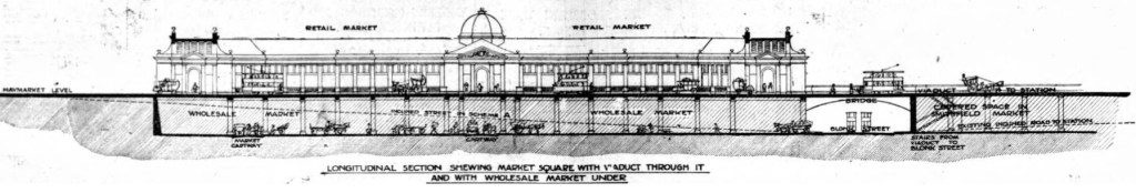
In response, the Sheffield architect Edward Michel Gibbs created an alternative plan whereby, instead of building the street at ground level, a new road could be carried on a viaduct, allowing the site beneath to be developed for market use.
“The street to the station would be similar in position to that recommended by the committee. It would run from Haymarket to Blonk Street, nearly in a direct line for the station, but instead of descending 26 feet to Blonk Street and then ascending 20 feet to the station yard, it would be carried on a viaduct on the level of Haymarket, then by a bridge over Blonk Street (26 feet high), and forward to a viaduct over the side of Smithfield Market to the station yard.”
A plan of the proposed Viaduct Scheme linking Great Central Station with Haymarket. (Image: The British Newspaper Archive)
The viaduct road would have resulted in level access to Great Central Station, avoiding traffic congestion in Blonk Street, and allowing for the expansion of the markets.
It was a radical scheme that also allowed for the creation of brand new market halls. A wholesale market would have been constructed underneath the viaduct, covering an area of 13,960 square yards, and built on part of the River Sheaf.
On top of the viaduct were to be retail markets, with bold balustraded parapets, and set back 40 feet on each side of the new street, fronting onto a decorative space almost as big as Fitzalan Square. With 5,555 square yards of selling space, the markets would have been bigger than the combined areas of the existing Norfolk Market Hall and Fitzalan Market.
A sketch of E.M. Gibbs’ Viaduct Scheme, drawn by local artist Alwyn Holland. (Image: The British Newspaper Archive)
Gibbs estimated the cost of the Viaduct Scheme to be £351,000, inclusive of land, road, viaduct, markets, and a new River Don Street from Blonk Street to Lady’s Bridge.
Unsurprisingly, Sheffield Corporation recoiled over the estimated cost (equivalent to over £16 million today) and refused to consider the scheme.
The Sheffield Daily Telegraph favoured the proposal and filled column inches with reasons why the council should at least consider it.
“There can be no doubt that the streets abutting onto the station approach are a disgrace to the town. They are dangerous, congested and filthily dirty, and they give the visitor to Sheffield a first impression of squalor and sordidness.
“If they alight at the station, what do they see? On the right a piece of wasteland: on the left a road that dips under the railway and is flanked with ugly stone walls; straight before them a sloping road leading to a narrow street of dingy, mean-looking buildings, with a dirty, battered ‘convenience’ of the worst and most ancient type standing proudly as a centrepiece.”
Gibbs published a pamphlet to convince people about the scheme and the council eventually agreed to discuss the proposal. However, the projected cost had increased to £398,000 and the Corporation went for the cheaper option.
The Sheffield Daily Telegraph was unimpressed.
“The Corporation have before them a scheme which is only a tinkering with an admitted evil, not a bold and generous attempt to extirpate it. It will suffice only for a generation or so.”
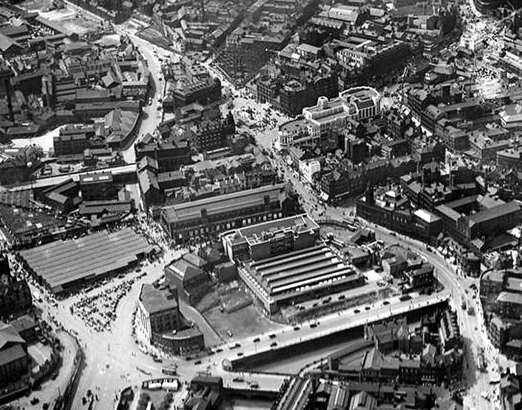
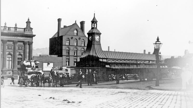
Unfortunately, World War One halted all plans for the markets, and it was not until 1930 that Castle Hill Market opened, subsequently replaced by Castle Market in 1959.
Castle Hill Market seen from the air in 1933. The new River Don Street in E.M. Gibbs’ Viaduct Scheme was the only part of the plan adopted by Sheffield Corporation. It was built in 1930 and became known as Castlegate. (Image: Historic England)
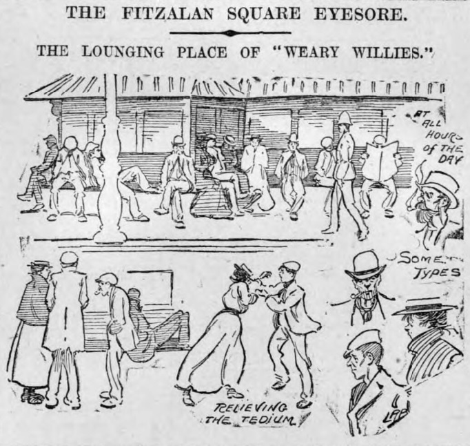
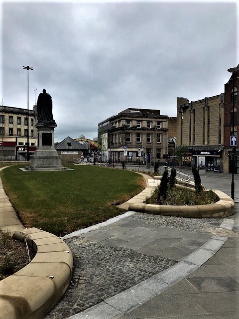
What do you do with a problem like Fitzalan Square? Those of you that have seen it lately cannot have failed to notice its recent overhaul with a new grassed area around the statue of King Edward VII, and the addition of new trees. The square has also been given open access from Norfolk Street, across Arundel Gate, and down Esperanto Place.
The improvements to Fitzalan Square and the surrounding area are part of a £5.5million ‘Knowledge Gateway’ project to transform the area which runs from the Cultural Industries Quarter up to the square.
However, there will be doubters that look upon this work with a note of scepticism. Fitzalan Square has never lived up to its name, not helped by unremarkable twentieth century buildings on one side of the square, and a tendency to attract ‘undesirables’.
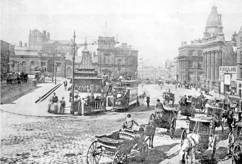
Its history goes back to 1869 when Sheffield Corporation started purchasing and demolishing premises on the east side of Market Street (where the top end of the square is now) and the south side of the old Haymarket.
Several properties came down, including the Star Hotel, Theaker’s Coffee House, the King’s Arms Hotel, the Blue Bell, Fisher and Sons, Mr Arnison’s drapery, and Mr Jeffrey’s pawnbrokers.
A large portion of the premises belonged to the Misses Shearwood. These two ladies objected to part with their property and refused to lend themselves in any way to the proceedings for acquiring it. Sheffield Corporation had to execute a deed poll vesting the property in themselves and paid money into a bank account for the benefit of the ladies. The Sheriff of Yorkshire was called in to give the Corporation possession of the property, and did so by placing in the street an article of furniture and getting the tenants to ‘attorn’ to the Corporation – that was to admit that the Corporation was their landlord. The money remained in a Bank of England account until the death of the ladies some years later.
When the property between Market Street and Jehu Lane (still standing off Commercial Street) was pulled down the open space was called Fitzalan Square, after the Duke of Norfolk’s family.
It was in 1882 that the council announced that it was obtaining plans and specifications for completing a new layout in the open space.
“The space will be levelled, and a retaining wall built along Market Street, surmounted with ornamental palisades, leaving a part open in the centre with steps down to the space levelled, at each of which is to be erected two small ornamental stone buildings, the one near the markets for the use of gentlemen, to contain a good reception or waiting room, lavatory, retiring and attendant’s rooms. The building at the other end near to Norfolk Street, for the use of ladies; to be provided with similar accommodation. The open space is to be well spaced with good flagstones, and in the centre a suitable fountain to be erected, or a statue to William Jeffcock, the first Mayor of Sheffield.”
It appears that the plans were rejected in full, the toilets not built, but some improvements were made to ‘Welshers’ Oval’, as the Sheffield Independent called Fitzalan Square.
“The police were asked to undertake the keeping of order in the open space,” said Le Flaneur in the newspaper. “I am afraid this open space will be very much like the proverbial white elephant. It certainly cost enough to get, and now a permanent addition of the police force will be necessary to keep it constantly free of the loafers, idlers and book makers that make it their daily resort.”
Photograph by Picture Sheffield
It was left to Police-constable George Warhurst to be the object of terror. Betting loungers were prompt to obey his orders to make themselves scarce, and it was a difficult task for the Chief Constable when Warhurst died in 1884.
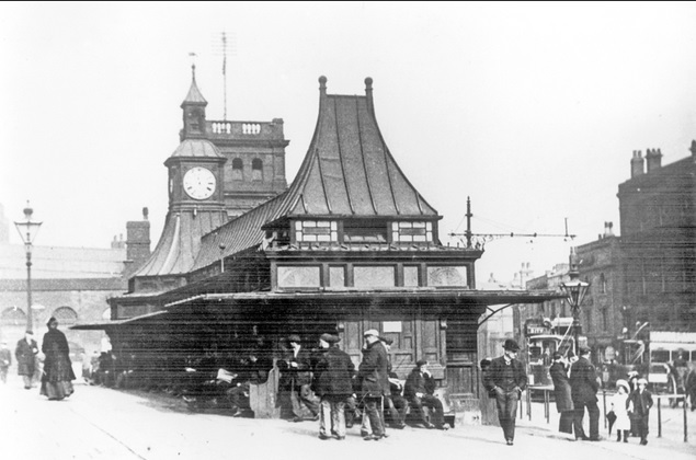
Matters did not improve after a pagoda-style building, comprising tram waiting rooms, water closets and urinals, as well as a clock turret, was built in the centre of the square in 1885.
Photograph by Picture Sheffield
Far from enhancing the appearance of the square, it provided shelter to ‘mouldy old men and frowsy women’ and in a short time had acquired a shabby reputation.
“If only some of our worthy Aldermen and Councillors would make it convenient to spend a few hours each day, for a week, in the immediate vicinity of this structure, they would, I am sure, be earnest in their endeavours to put an end to the constant ‘loafing’ which takes place by ‘undesirables’ at this particular sport,” said one letter to the Sheffield Daily Telegraph.
Photograph by Picture Sheffield
It was a subject repeated day after day.
“The evil at the shelter is a radiating evil. It embraces all the seats around, for the reason that, while the shelter is the converging point of the very pick of Sheffield’s undesirable characters, they also use it as a kind of base from which they carry on their predatory prowling: a long rest, then a short spell of loafing at the street corners, – that is the day’s programme.”
And
“It has been a disgrace far too long, and from every point of view. In my judgement the lavatories themselves are a menace to public decency.”
The ‘Current Topics’ column in the Sheffield Daily Telegraph took up the matter and its biting words make painful reading today.
“The correspondents who are raising the question of this unpicturesque resort of the city’s Weary Willies and Tired Tims will do good service if they can stimulate the authorities into action. We will confess that we never pass through Fitzalan Square without experiencing a keen desire to turn a hose pipe on those seats, partly because it would be a pleasing novelty to see the people run, as in their abhorrence of cold water they would, and partly because both they and the seats they occupy look as if they would be the better for a smart wash.
“There need be no sentiment wasted over the denizens of Fitzalan Square. When we are really civilised, we shall transport such people to Labour Colonies and give them to eat exactly what they earn. Failing that there is neither reason nor sense in retaining them as permanent decorations to the city’s ‘finest site’. Fitzalan Square might be something to be proud of. At present it is only disgusting.”
Illustration from 1903 by The British Newspaper Archive
Sheffield Corporation was indeed stimulated into action, probably the result of land at one end of the square being chosen as the site for the new General Post Office.
While land was cleared for the Post Office in 1907, councillors proposed reconstructing Fitzalan Square to harmonise with the new building.
It was probably one of the best known public spaces in Sheffield, but the most ardent son could scarcely claim that the pagoda-like structure which gave it its chief characteristic had added either architectural grace or dignity to this part of the city.
“The pagoda had served various purposes satisfactorily, and, notably, as a rendezvous for a little army of folk with apparently little to do than doze and gossip the day through.”
The council adopted a scheme for laying out Fitzalan Square in ornamental style as an open space, and at the same time taking advantage for utilitarian purposes. The scheme was worked out by Mr C.F. Wike, City Engineer, based on drawings prepared by the Sheffield Society of Architects and Surveyors.
At the time it was noted that there were more pipes laid through Fitzalan Square than through any part of the city. Here, the lines to the GPO, the National Telephone, and Electric Light Power stations converged. The Post Office was also laying cables to connect trunk wires to the new GPO building and on completion of work, in January 1909, renovation of the square commenced.
The contractor chosen for the work was George Longden and Son, but the original plan had been shorn of ornamental detail due to cost, although the property overlooking the square was nearly all rebuilt.
The ugly pagoda went and the central part of the square it occupied was enlarged. This was made possible by removing an old cab stand and filling up the slope on the south side of the square to make it level and wider.
The upper part of Baker’s Hill, a sloping road in front of where the new GPO was being built, had been done away with, and steps substituted as an outlet from that corner of the square into Pond Street.
Illustration from 1908 by The British Newspaper Archive
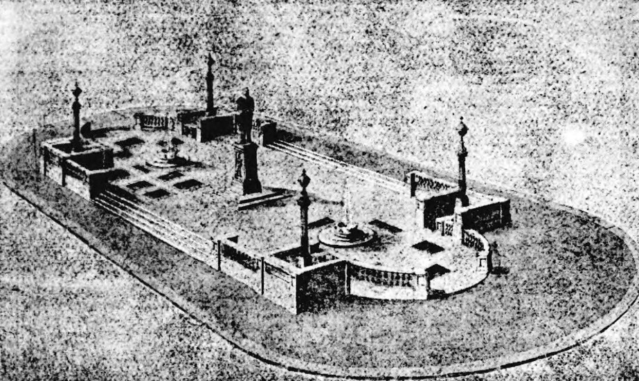
The new scheme provided an ornamental stone balustrade, public conveniences at either end of the square, and a tramway office, all underground. At the four corners were electric arc lamps, with further embellishments, in the shape of a fountain and a statue, planned for a later date.
Photograph by Picture Sheffield
However, the scheme was embroiled in controversy, the council wanting to use Norwegian or Swedish granite because it resisted damage, but the majority wanting cheaper Stoke Hall stone. In the end, the balustrades were built of imported granite.
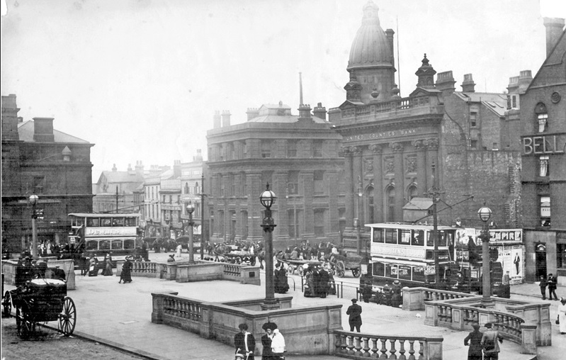
Fitzalan Square was formally opened on Wednesday December 8, 1909, by the Lord Mayor, Earl Fitzwilliam, at which he made an expressive speech: –
“We live in a time when the question – a burning question in some cities – of open spaces is bidding fair to see some very satisfactory accomplishment. In no city more than Sheffield are these open spaces desirable. In a city like Sheffield where we burned the very best ‘South Yorkshire’, they made the very best mess of the South Yorkshire atmosphere. Science has not yet taught us how altogether to avoid this murky effect, but by providing open spaces we might make best of the atmosphere that is left to us. Sheffield is especially fortunate in its open spaces and in this particular one, because although in the past they had had a space here, it had not been one worthy of the size or importance of the city.”
The improvements had cost £9,000 (about £1.1 million now), but the age-old problems refused to go away, and criticism was often scathing.
Photograph by Picture Sheffield
Photograph by Picture Sheffield
“Within a year an article appeared in the Sheffield Evening Telegraph, written by an anonymous correspondent, under the heading ‘THAT SQUARE’: –
“A good deal of the recent talk about Fitzalan Square may have been ineffectual, but if it did nothing else it sent me to inspect the place. Though my work brings me into the city daily, I had never had reason to descend to the bottom of High Street since the so-called improvement had taken place. Yesterday I determined to see for myself what the fuss was all about.
“I have no desire to exaggerate but I do not hesitate to say that Fitzalan Square is the most pestilently ill-favoured open space in England. This is patent without seeing all the others, for there is an instinct which tells you when you have seen the absolute nadir of ugliness. I have seen IT.
“If you are at all run down the effect of suddenly coming upon such a spectacle as this forlorn wilderness of paltry dog kennels and pretentious architectural incoherencies may easily cause a shock dangerous to health.
“The said ‘improvement’ consists of a stone balustrade round a large piece of nothing at all. What this petty stone fence is meant to enclose or exclude is not obvious. There are four lamp-posts of the most abysmal hideousness. Possibly there is poetic fitness in this, for they are meant to light the way below.
“It might be roofed in and let as a skating rink or turned into a rifle range. It might be dug up and let out to husbandmen. Unless three out of four of the surrounding buildings are absolutely wiped out and a big sum spent in covering up the alleged ‘improvement’ which has recently been carried out, nothing can be done to make the place decent.”
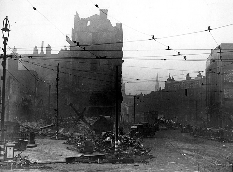
Wartime bomb damage. Photograph by Picture Sheffield
Photograph by Sheffield Star
And so, the tone was set, for decades subject of ridicule, damaged during the Blitz, and often left to its own unsavoury devices.
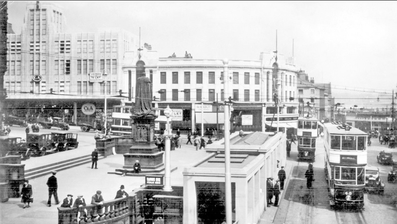
The fountain never materialised and a plan to relocate a statue of Ebenezer Elliot from Weston Park to Fitzalan Square was abandoned. It was graced with a statue of King Edward VII (subject of another post) in 1913.
In time the underground toilets were removed, the trams disappeared, and even the taxis left for busier parts of the city centre.
Photograph by Picture Sheffield
Photograph by Sheffield Star
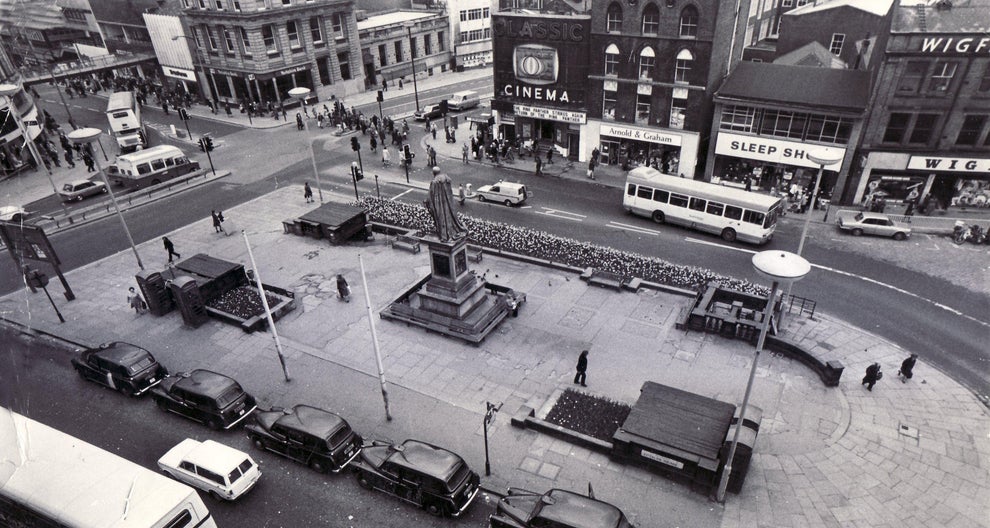
When the area has become too down-at-heel there have been attempts to restore it, including a 2003 facelift, with the restoration of the King Edward VII statue, new sandstone paving, steel benches and improved street lighting.
The latest restoration comes at a time when this part of the city centre is in transition. A vast proportion of people have migrated to The Moor along with the old market, the old General Post Office now belongs to Sheffield Hallam University, and the future depends on the Castlegate development and most probably our student population.
Fitzalan Square in 2020. Photograph by David Poole
Photograph by Sheffield Midland Station and Sheaf Valley Development Framework.
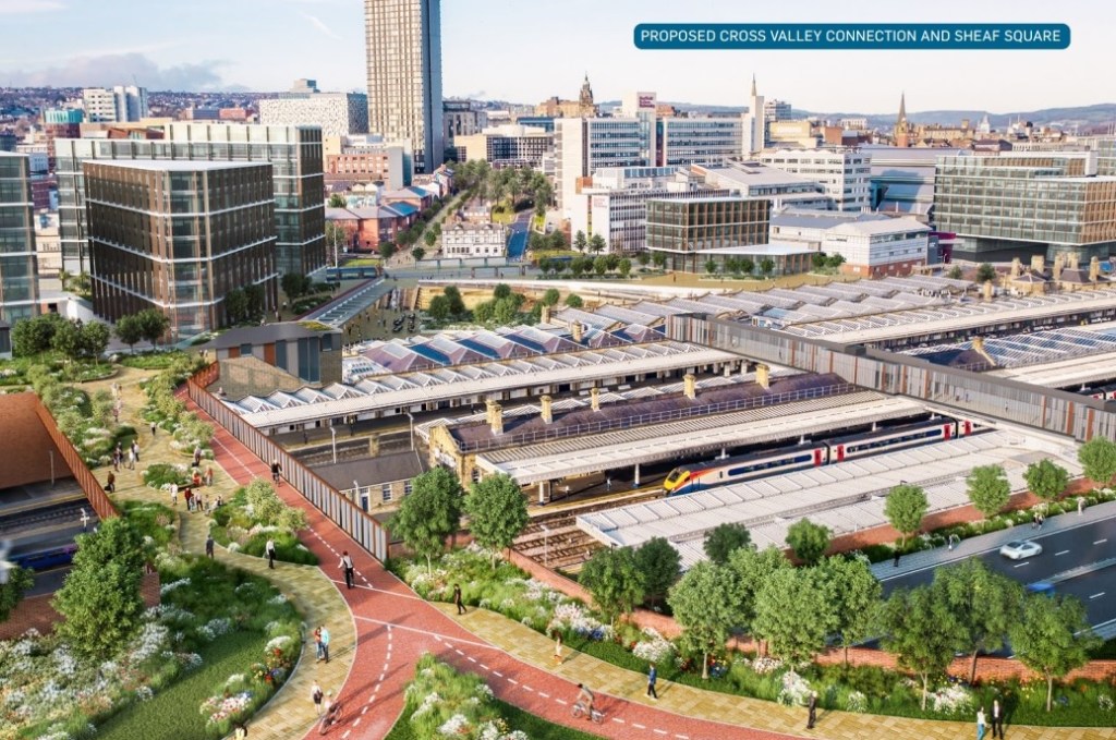
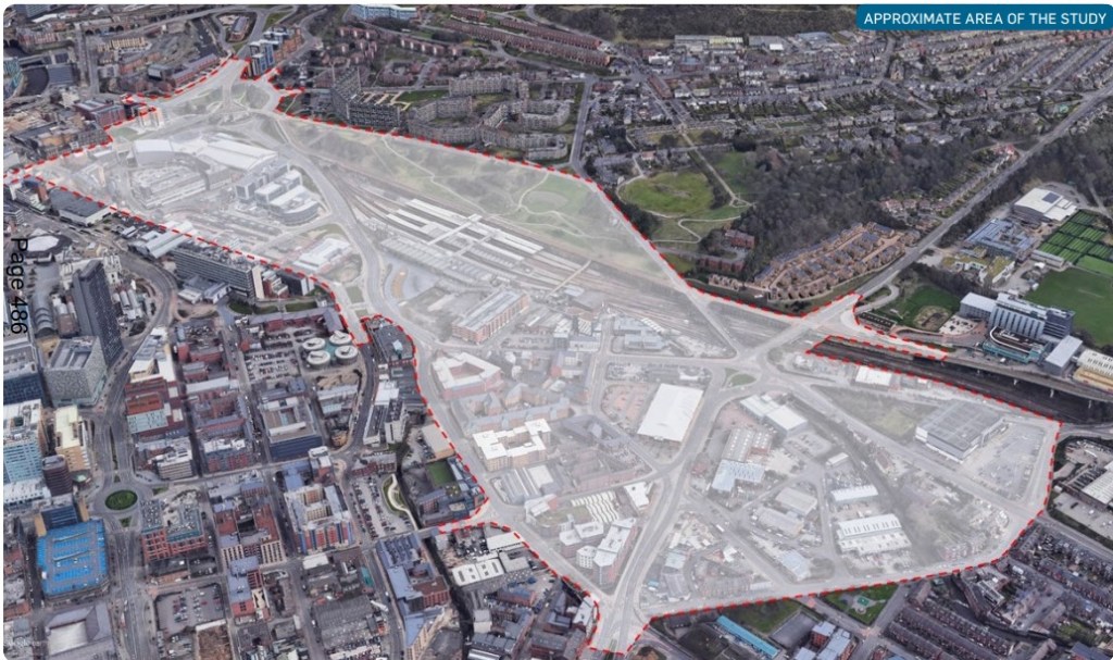
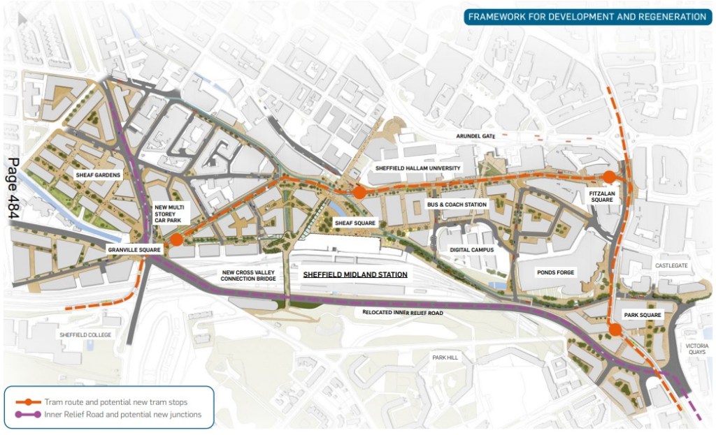
I don’t think anybody saw this coming. Sheffield’s biggest ever development project – a £1.5bn plan to develop the area around Sheffield Railway Station, dwarfing the £480m Heart of the City II scheme.
The plan is to maximise the economic potential of the area and make the most of HS2, and will now go out for public consultation.
The idea stems from plans for HS2 trains to stop at Sheffield Station on a loop off the mainline which were recently given the green light by the government.
Sheffield City Council would co-ordinate the project, with funding coming from several organisations including the city council, HS2, SYPTE, Transport for the North, Network Rail, Sheffield City Region and the Department for Transport. The bulk of the costs – up to £1bn – would be from the private sector, which would build offices, restaurants, bars and potentially a hotel.
Photograph by Sheffield Midland Station and Sheaf Valley Development Framework.
The project would see the closure of Park Square roundabout and Sheaf Street – the dual carriageway that runs in front of the station – would swap places with the tram route that runs behind.
A huge, landscaped pedestrian bridge would link Park Hill with Howard Street and the multi-storey car park on Turner Street would be demolished and moved further away.
It would be replaced by an office block – one of up to 12 planned in the ‘Sheffield Valley’ zone, including four outside the station, employing up to 3,000 people.
Up to 1,000 homes – flats and houses – could also be built.
Photograph by Sheffield Midland Station and Sheaf Valley Development Framework.
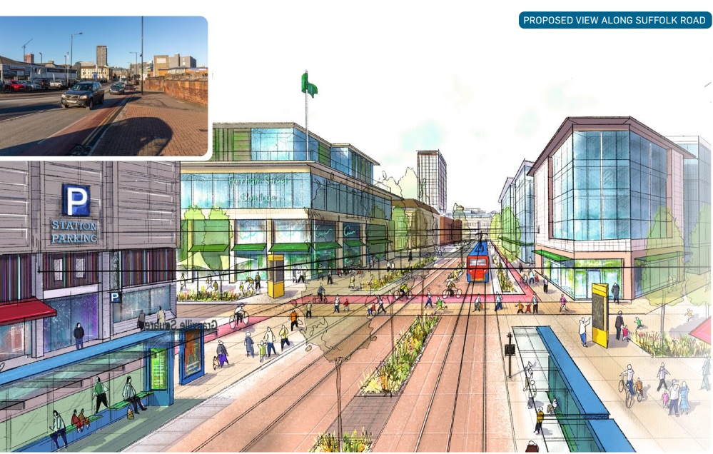
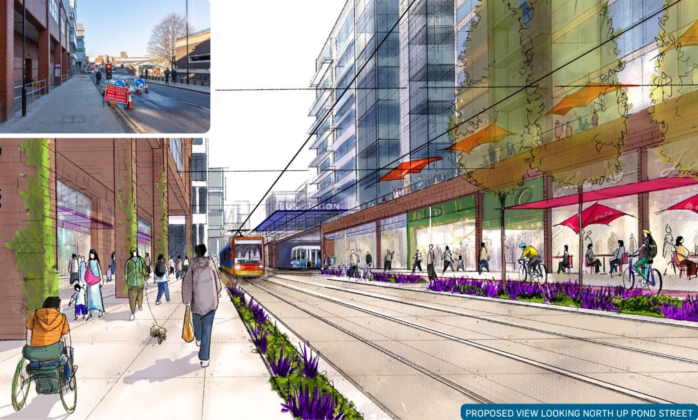
The new tram route would run from Fitzalan Square, along Pond Street, stop outside the station and continue along Suffolk Road to Granville Square.
The bus station on Pond Street would be reduced in size to make room for the tram tracks and offices on stilts potentially built on top.
Photograph by Sheffield Midland Station and Sheaf Valley Development Framework.
Park Square roundabout and Sheaf Street would become a park and link into the Grey to Green scheme at Victoria Quays, Castlegate and West Bar.
Under the plans the ‘Q park’ would move to the Wren-DFS site on nearby St Mary’s Road.
There would be a new, sheltered, taxi rank next to the station, but the taxi ‘stacking’ area would be moved ‘slightly further out’ improving access for drop-offs and people with mobility needs.
The area between St Mary’s Road, Queens Road and Sheaf Gardens, currently home to businesses including a Pure Gym, would be a new residential centre for up to 700 homes, with a further 300 spread throughout the area.
We’ve already had a look at the series of culverts and tunnels that hide the River Sheaf underneath Sheffield city centre.
The last part of the river to be covered was the stretch from the Megatron, underneath Exchange Street, towards the confluence of the River Don at Blonk Street Bridge.
This was covered in 1916 after the demolition of the Alexandria Theatre, another massive scheme that allowed the eventual construction of Castle Market above, the rebuilding of Blonk Street and a tunnel entrance that allowed the Sheaf to flow straight into the Don.
Following the demolition of Castle Market in 2015, Sheffield City Council announced that a park would be created between Castlegate and Exchange Street.
Alas, four years down the line, the plans are still on the table, but the council is committed to delivering the project.
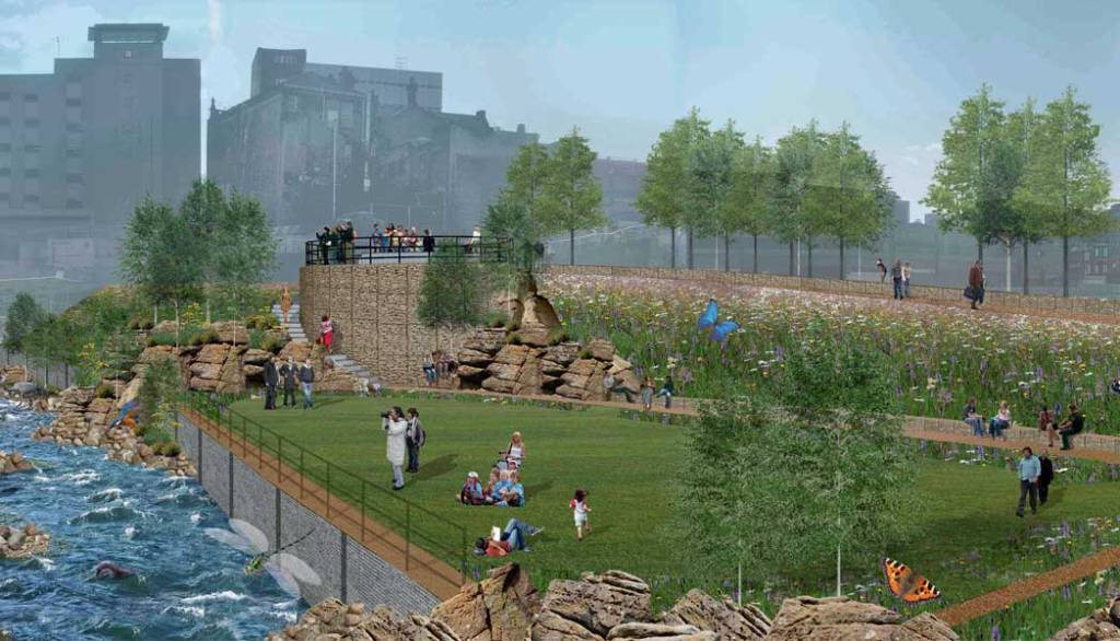
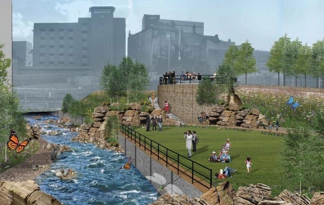
Sheffield Council wants to take the roof off the underground culvert, which the river currently runs through and is in a poor state of repair, and bring the waterway back into the open, surrounded by grass, flowers, trees, seating and other landscaping. The aim is to make the area more attractive to visitors, bring in new investment and reduce the risk of flooding.
The scheme would also complement the proposed Castlegate development on the site of the former market, which the council and its partners are still pursuing, and which will feature the exposed ruins of Sheffield Castle.
The park has the working title of Sheaf Field.
A waterside meadow and an elevated viewpoint would be created at the waterside and low stone walls built overlooking the river. The weir within the Sheaf culvert will be lowered, and the river channel remodelled, to improve natural habitats.
The plans also involve using way markers or pavement art to follow the River Sheaf’s course where it remains in a tunnel under Castle Square, Sheaf Street, the railway station and through Granville Square. Also, temporary art installations and ‘interactive sound experiences’ could be set up in the Megatron.
In 2019, the Sheaf and Porter Rivers Trust was set up to promote and support the deculverting and improve the environment of the River Sheaf and Porter Brook. The group’s founders aim to open the waterways and are trying to recruit as many members as possible to help make that happen. One of their hopes is to make sure that Sheaf Field comes to fruition.