Categories
Places

“Best not to explore as there are rumours that the Old Bramall Lane Bridge troll eats anything.”

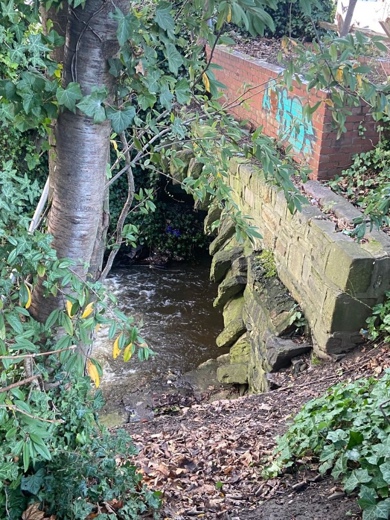
Bramall Lane Bridge, near former Staples Car Park. Image: DJP/2023

It was one night last summer, and I was taking photographs of skateboarders who had requisitioned the former Staples car park at the corner of St. Mary’s Gate and Eyre Street. There were about thirty of them, showing off to each other, trying to be cleverer than the next.

A small group noticed my interest and obliged by making their skateboards do remarkable things, but the resulting photos weren’t particularly good and soon forgotten.

Staples had long gone, so had Office Outlet that replaced it, and we forget that Mothercare had a shop here, later home to Theatre Delicatessen. The retail park was emptied, bought by Lidl for a new store, but plans had faltered, and the site had surrendered itself to broken windows and graffiti, hastening the rapid descent into decay.

Wooden gates had been erected, preventing entry into the car park, and allowing skateboarders to takeover.

The recent posts about St. Mary’s Church and Ladies’ Walk made me think about the conversations I’d had that night.

Taking a breather from their enactment, three boys sat on the tarmac, drinking bottled water, and chatting about their hallowed space.

I told them that where they were sitting had once been Ellin Street, still listed on maps, named after Thomas Ellin, who used waterpower from the adjacent Porter Brook where it widened into Bennett’s Dam. Here, he founded Vulcan Works with cutlery shops and a steel furnace, and the makeshift skateboard park was where the dam had been.

“That’s cool,” one said, “the dam disappeared, but the river’s still here.”

He was referring to nearby Porter Brook, and the reason Lidl withdrew their planning application last autumn. The discounter was aggrieved about calls to deculvert the river where it flowed under the site, with the loss of car parking spaces .

On the other side of Porter Brook is St. Mary’s Gate, where I took them to see an information board about an ancient structure called Bramall Lane Bridge. Like many Sheffielders, they had no idea about it, and were surprised to learn that it still existed, yards from where they skateboarded.

“Look here,” one of the boys said, pointing to a tongue in cheek warning on the sign.

“Best not to explore under the bridge as there are rumours that the Old Bramall Lane Bridge troll eats anything, especially with her carefully guarded bottle of Henderson’s.”

When told not to do something, lads of that age will do the opposite.

Days later, I saw them again, and they told me that they’d followed the river under the bridge, and then bottled it for fear of meeting the troll that protected it.

Their reaction is common because people don’t realise that Eyre Street, where it joins Bramall Lane Roundabout, is really built on a bridge that starts at the edge of the former Staples car park and ends on the other side of the dual carriageway near Decathlon.
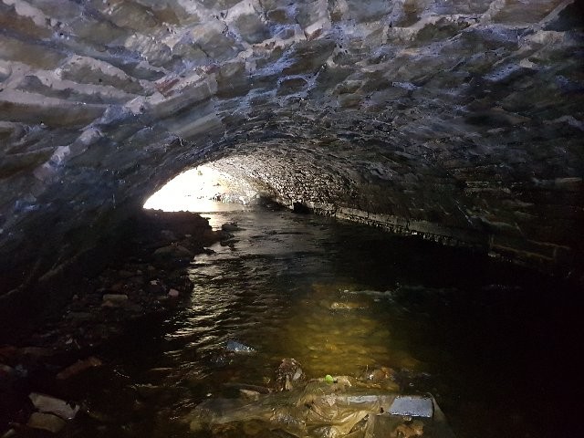
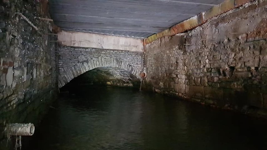
The underside of Bramall Lane Bridge looking towards the former Staples car park end. Image: South Yorkshire Local Heritage List

These days, there is a Friends of Bramall Lane Bridge Facebook group that is responsible for the information board, and for getting the bridge listed on the South Yorkshire Heritage List. That was no mean feat because until the group had applied for its listing, the heritage body was also oblivious to its existence.

But what of its history?

I remembered a letter that had been published in the Sheffield Independent from 1831: –

“Permit me, Sir, through the medium of your valuable miscellany, to call the attention of the Town Trustees and others to this hitherto neglected, though now highly improving part of town. The bridge over the river Porter cannot remain as it is, and if all the owners of adjacent property were to come forward, I am certain the town trustees would not be appealed to in vain for their assistance in connecting Eyre Street, by means of a quadrant or an angle, with Brammall Street. This may be accomplished at considerably less expense than might be at first imagined, and most assuredly it would not only very much increase the value of property in the neighbourhood but would become a highly acceptable substitute for Porter Street, at the entrance to the new part of the town, by throwing open to view that most elegant structure, St. Mary’s Church.”

The letter showed remarkable foresight and within years, a new bridge had been built and Eyre Street eventually connected with Bramall Lane. Had this not been the case, then Bramall Lane might never have become home to Sheffield United FC.

The bridge’s history goes back to days when this was countryside, still a distance from the town that ended where Moorhead is now. At this time, Porter Brook had to be crossed by a narrow wooden footbridge, and horses and carts had to splash through the water to get to the other side.

When the file manufacturing Brammall family built White House and Sheaf House (now a pub), the road leading to the houses became known as Brammall Lane, later shortened to Bramall Lane, and extended across the Porter and would have finished near to where Moor Market is now.

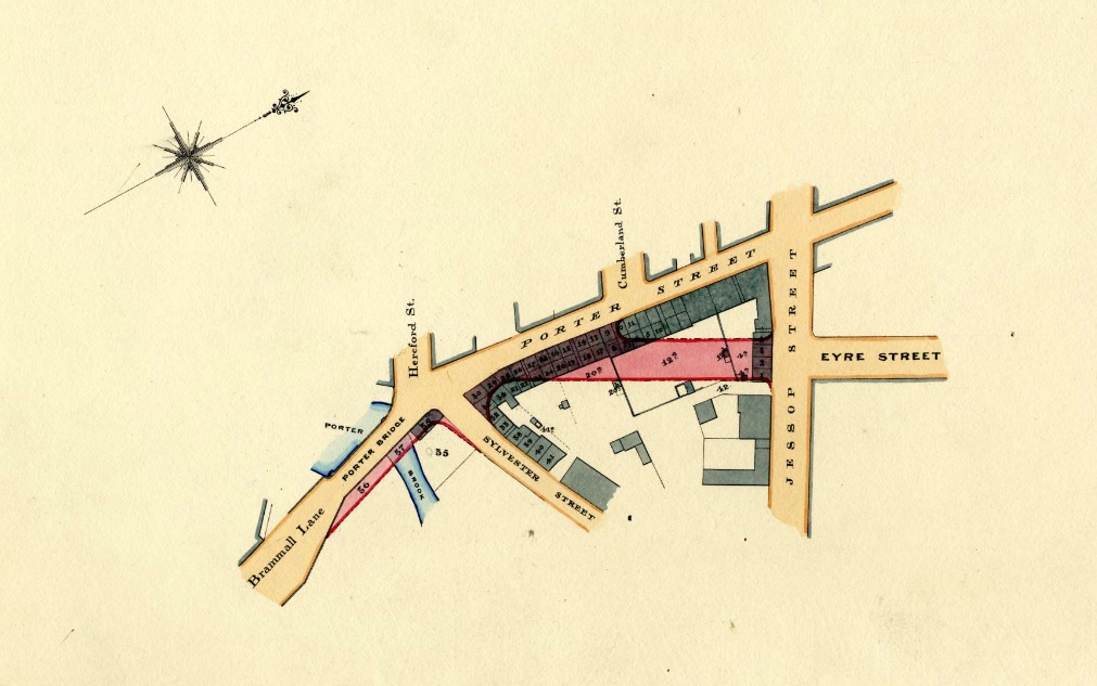
By the 1835 Highways Act, Sheffield Corporation was allowed to replace a wooden bridge with a stone-built structure, and is thought to have been completed by 1845-1846, opening land for development to the south of the town, in places like Highfield, Little Sheffield, and Heeley.

For a long time, it was known as Porter Brook Bridge, and was widened in January 1864, but there were already concerns that the bridge might not be strong enough to carry the traffic that might pass over it. The bridge was now 100metres wide and curved as it followed the course of the river.

This was the height of the Industrial Revolution, and rural land had been swallowed by the town. In 1876, Sheffield’s Medical Officer, F. Griffiths, reported that Porter Brook was full of sewage and the putrid remains of cats and dogs.

In 1877, the Corporation proposed plans to demolish houses between the west of Eyre Street, and the junction of Hereford Street, Porter Street, and Bramall Lane, allowing the extension of Eyre Street to the Bramall Lane Bridge where roads converged.

Once the roads connected, factories and houses were built, even on the bridge itself, but these have long disappeared, and the modern landscape is quite different.
These days, the only visible signs of the bridge are near Staples car park because the other end remains hidden, and most people are oblivious that Eyre Street runs directly over it.

Halfway under the bridge is the well preserved tail goit from the old Vulcan Works (Staples site) that joins the riverbank and has yielded finds such as a Victorian inhaler and oyster shells.

There is also a visible join in the structure about 25metres from the Decathlon end (75metres from the Staples end) that is thought to be the 1864 extension, while the Porter was culverted further from the Decathlon end of the bridge from the 1890s onwards.

Bramall Lane Bridge has stood the test of time, unlike the later culverted section that famously collapsed, forcing part of the Decathlon carpark to remain closed.

The Staples car park is now fenced off and the skateboarders have gone. This week Lidl announced that a revised planning application is pending, and it might include deculverting of another stretch of Porter Brook.
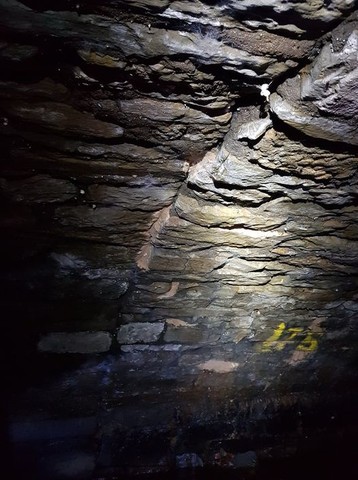
Joint in structure, towards Decathlon end. Image: South Yorkshire Local Heritage List
The other end of the bridge, hidden from view under the Decathlon car park. Image: South Yorkshire Local Heritage List

©2024 David Poole. All Rights Reserved.

Categories
Buildings

“The children spent a warm spring afternoon playing beside the river.”

Platform_, Sylvester Street, Sheffield. Image: DJP/2022

“The children spent a warm spring afternoon playing beside the river. And when their energy was spent, they trod wearily the path across Alsop Fields, passing the old farmhouse that had once belonged to Aulsope Farm.”

This might have happened 300 years ago, and nothing remains of it except Porter Brook.

The large steel structure rising above Sylvester Street, on the outskirts of Sheffield city centre, is the latest chapter in the city’s development. A rural idyll, swallowed by the advancing town, used for industry, and when this declined, utilised for residential.  

The Sylvester Street development is a £75m plan to construct 335 ‘build to rent’ upmarket apartments alongside Porter Brook.

More importantly, once completed, a stretch of the river will be spruced up and opened to the public.

The developer promises to plant vegetation along the edge and place rocks in the middle to slow down the water’s flow and reintroduce habitats for wildlife. A new pedestrian route will run parallel to the river, with a bridge allowing people to access the new buildings. The brook will remain culverted in places – here open spaces are to be created.

It will be respite for the river that suffered at the hands of Sheffield’s industrial development.

Platform_, Sylvester Street, Sheffield. Image: DJP/2022

In 1789, a building called Sylvester’s Wheel stood nearby, land to the west was Joseph Broomhead’s garden, and land to the right was owned by Robert Walker. During the 1800s, Porter Brook was used to power industry and larger scale industrial buildings started appearing including Sylvester Works, Thomas Ellin, and the Oak, Stella, and Crown Steel Works.

By the end of the twentieth century, the downturn in Sheffield’s metalworking industry was reflected in the clearance of most of the site. In 1994, a large retail shed was built on the former Crown steel works, occupied by Carpet World and subsequently by Sofa World. This was demolished about 2009 as were most of the remaining industrial works.

And now, this massive residential development rises above this long-lost green space.  

© 2022 David Poole. All Rights Reserved

Categories
Buildings

Ellin Street: Change ahead for the forgotten Sheffield street

Ellin Street can be seen in this satellite image. The road starts at the entrance to the retail park and follows the line in front of the building. Photograph: Google Earth

Is an outlying part of Sheffield city centre about to be redeveloped?

Theatre Delicatessen and the Forces Support charity shop have been served notice to vacate their premises on Eyre Street by January 2022. Both units were once branches of Mothercare and Staples (later Office Outlet).

It is understood that both properties are owned by NewRiver and Bravo Strategies, which bought The Moor, the adjacent 28 acre estate for £41m.

The former retail park will almost certainly be demolished and there is speculation that it will be replaced with a new Lidl supermarket. Any redevelopment will be subject to planning permission.

Earlier this year, the discounter urged landowners to come forward with the focus on ‘town centre, edge of centre, retail park and metropolitan locations’ which are prominent, easily accessible and have a ‘strong pedestrian or traffic flow’.

Areas of interest included Beauchief, Broomhill, Burngreave, Chapeltown, city centre, Crystal Peaks, Ecclesall, Ecclesfield, Fir Vale, Fulwood, Gleadless, Handsworth, Hillsborough, Holbrook/Mosborough, Meadowhall, Norton and not surprisingly, St Mary’s Gate.

The site was once Ellin Street (still listed on maps) and edges Porter Brook. It was named after Thomas Ellin who had used water power from the Porter where it widened into Bennett’s Dam. Here he founded Vulcan Works with cutlery shops and a steel furnace. The dam, roughly where St Mary’s roundabout is now, was later covered over and the Porter culverted to Leadmill Road.

Categories
Places

Little Sheffield

Fairbanks’ Map of Little Sheffield in 1808. South Street became The Moor. The road marked Little Sheffield is now London Road. There are some familiar road names in the top half of the map. (Image: Picture Sheffield)

Once upon a time there was a small hamlet near Sheffield town that went by the name of Little Sheffield.

During the early 1800s, Sheffield’s rapidly growing population needed to expand outside the historical boundaries, and Little Sheffield disappeared.

We know where Little Sheffield was, but its boundaries blurred over time, with experts long contesting where it started and finished. The area has never been clearly defined, like those forgotten places of Port Mahon and Hallamshire.

We must go back to olden days when Sheffield was a town surrounded by fields and countryside. It gradually expanded until its southern edges skirted a gorse-clad swampy common called Sheffield Moor.

Today, we know this marshy land as The Moor with its surrounding streets.

A path was made by throwing up two embankments, between which was a deep ditch, with only a footbridge over Porter Brook.

By the 1760s, travellers had to go down Coal Pit Lane (Cambridge Street) and Button Lane (long disappeared) to Little Sheffield – a group of poor and time-worn cottages. The road to it ran across Sheffield Moor, thence up a sharp rise to Highfield. The only house you came to after passing Moorhead was Mr Kirkby’s, standing on Button Lane (opposite where the ramp to Sainsbury’s car-park on Charter Row now stands). There was one other building nearby, with a bowling green attached to Sheffield Moor. Beyond was Little Sheffield, the outlying hamlet.

By the nineteenth century, the fields around Little Sheffield had been swallowed up for the working classes, a poor and densely populated area, its houses with roofs of stone slabs, low windows, and red brick walls.

Nowadays, we can define Little Sheffield’s northern boundary as being where the Moorfoot Building stands, taking in Young Street, South Lane, St Mary’s Gate, London Road, and surrounding streets like Hermitage Street, Sheldon Street, Hill Street, John Street, and Boston Street (once called George Street), up towards its southern boundary at Highfield.

© 2021 David Poole. All Rights Reserved.

Categories
Places

The fig trees of the River Don

When our industrial ancestors enjoyed eating fig biscuits, they didn’t realise that they would leave a legacy for us.

Alongside the banks of Sheffield’s River Don, towards Meadowhall, are about 30 mature fig trees, some about 70-years-old, which owe their existence to a combination of human appetite, imperfect sewage and the steel industry.

Fig biscuits were popular amongst steel workers. The fig seeds passed through their digestive system, and each time there was a heavy storm a proportion of sewage overflowed into the river.

At the turn of the 20th century, because of industry alongside the River Don, the waters of the east end were at a constant twenty degrees creating perfect conditions for the fig seeds to germinate and grow.

And they’re not just confined to the Don, with fig trees also found on Porter Brook and the River Sheaf.

Categories
Places

Into the Megatron (1)

Most of us known about Megatron, a Victorian-engineered labyrinth of storm drains with cathedral-like brick archways and interconnected dark tunnels to contain the overflow of water. (Although officially, the Megatron is one huge chamber further up the network).

Seemingly forgotten for years, this complex system of underground waterways, gained worldwide attention when it was “rediscovered,” becoming a favourite for urban explorers, and even attracting guided tours.

The misconception is that these subterranean drainage channels were built in the mid-1800s, an effort to channel the huge flow of water from Sheffield’s three main rivers – the Don, Sheaf and Porter, but the real story is very different.

Let’s start with the Porter Brook, with its source on Burbage Moor, descending into Sheffield before disappearing into culverts in the city centre. During the late 19th century, sections of the Porter were covered over, partly because the water supply was so poor and had become a sewer, but also to allow for the construction of factories above.

The Porter Brook joins the River Sheaf, the river that gave Sheffield its name, in the Sheaf Valley at a location that becomes evident later.

The Sheaf Valley had historically been prone to severe flooding, the areas around Pond Street and Ponds Forge, particularly susceptible when the River Sheaf burst its banks, and rendering much of the land unusable.

The River Sheaf flows through Sheffield, joining the mighty River Don at Blonk Street Bridge, near to where old Castle Markets stood, and the site of long-lost Sheffield Castle.

Our story really begins with the arrival of the Midland Railway Company, connecting Sheffield with London, which had blundered on its original route, inconveniencing passengers to change at Rotherham Masborough Station and take a branch line to The Wicker.

By the late 1850s, the company made proposals to rectify the matter, bringing the direct line into Sheffield. The site chosen for the new railway station caused disbelief as it was in the valley through which the River Sheaf flowed.

In the 1860s, after gaining Parliamentary consent, land was cleared on a site that was bounded east by Granville Street, on the west by Pond Lane, at north by Harmer Lane, and south by Turner Street.

The platforms were to be built where the River Sheaf flowed, and so the whole distance of the river between Harmer Lane and Turner Street was spanned by three arches and then covered over. The Porter Brook was spanned with two arches, also enclosed, and a portion of the nearby Bamforth Dam (now Sheaf Square) was filled in.

“For months and months past, seeming chaos has reigned in Granville Street and the region adjoining. Thick-booted, muddy-smocked navvies have laboured along in dust and mud, fine weather and wet, pulling down houses and the foundations on which they stood, tearing up banks, blasting rocks, making huge caverns which they said were to serve for tunnels, heaping up and then carting away great mounds of earth. The lines of the rails will run over the bed of the River Sheaf, which is degraded to the condition of a sewer. The work is being undertaken by Messrs. Chadwick and Thurwall for £20,000.”

The Midland Station, now Sheffield Station, opened in 1870, its passengers forgetting that the River Sheaf flowed under their feet (now Platforms 5-8), before emerging again after Harmer Lane.

It was a huge success and by the late 1890s the Midland Railway Company was planning the expansion of the station, and the widening of the tracks.

In 1899, the land in front of the station was cleared and between 1900-1903 its facade was built further forward and surrounding land used for railway business.

The River Sheaf, between Suffolk Road and the Midland Station was arched over and covered, as was a section running underneath Sheaf Street towards Commercial Street. A little-known stream, Pond Brook, between Station Road and Harmer Lane was also diverted through another large culvert.

More importantly, the confluence of the Porter Brook and Sheaf was also covered and is now underneath the south end of Platform 5, close to where Platform 2A is. Thank you to Phil Jones, who volunteers for the Sheaf and Porter Rivers Trust, for explaining that today there is a large square wooden access cover, exactly over the confluence.

As to who funded what, is a matter of debate, but it is likely that the “sewer” system, as the River Sheaf was ingloriously relegated to, was funded and built by Sheffield Corporation.

And so, the first parts of the underground maze were completed, and hereon becomes something of mystery.

Categories
Places

Into the Megatron (2)

We’ve already looked at the building of Sheffield’s underground tunnel system around Sheffield Station and the ingenious method of “hiding” the Porter Brook and River Sheaf. (Available to read on a separate post).

In this post, we move on from Sheffield Station (formerly Midland Station), which had doubled in size in the first few years of the twentieth century, and resulted in long stretches of the River Sheaf bidding farewell to the light of day.

After the Midland Station, the River Sheaf emerged briefly at a weir, as it does now, close to what is now the Digital Campus.

It then flowed through further culverts under the Electric Light Works (now the front of Ponds Forge International Sports Centre). The river then streamed under Commercial Street and beneath what was once the site of Sheaf Market (now the Travelodge).

Onwards it flowed under Castlefolds Markets, until being freed at Exchange Street and flowing open-air until meeting the River Don at its confluence near Blonk Street. (Remember that the River Sheaf once ran alongside Sheffield Castle).

As elaborate as the underground tunnels were underneath Sheaf Valley , the most spectacular part of the network lay underneath Exchange Street, now known as the “Megatron Chamber” – “something excellent and impressive” – a massive arched brick-lined cathedral that dwarfed any man who stood inside.

The reason for the Megatron has been provided by Heather Smith and Phil Jones from the Sheaf and Porter Rivers Trust. It seems that the giant Megatron arch was built for a very specific purpose, to carry heavy old trams across the river on Exchange Street, which rises slowly up the hill, and get them into the city.”

From the Megatron, the River Sheaf flowed out into the open-air, past the old Alexandria Theatre. This last section was culverted over in 1916 after the demolition of the theatre, another massive scheme that allowed the eventual construction of Castle Market above, the rebuilding of Blonk Street and a tunnel entrance that allowed the Sheaf to flow straight into the Don.

The underground system of tunnels is Victorian engineering at its best.

The arched roofs were built with three layers of brick, strong enough to resist the huge torrents of water that the Porter Brook and River Sheaf threw at them during times of high flood.

Alas, as good as the system is, it has failed on occasions, with stories of the old Sheaf Markets flooding at high water, and then there was the memorable Sheffield flood of 2007 when Sheffield Station found its tracks underwater for several days.

A poignant reminder from the River Sheaf that it is still around.

Mostly, the tunnels are accessible to walk through, but should never be entered without permission and expert supervision.

Underneath Sheffield Station the sound of trains can be heard rumbling overhead, and in the lower reaches, bats skim the surface of the Sheaf with fish evident.

As part of the Returning Rivers to the City Scheme, Sheffield City Council is considering reopening the last few yards of the River Sheaf from the Megatron to the River Don, in a park to be called Sheaf Field.

Categories
Places

Sheaf Field Park

We’ve already had a look at the series of culverts and tunnels that hide the River Sheaf underneath Sheffield city centre.

The last part of the river to be covered was the stretch from the Megatron, underneath Exchange Street, towards the confluence of the River Don at Blonk Street Bridge.

This was covered in 1916 after the demolition of the Alexandria Theatre, another massive scheme that allowed the eventual construction of Castle Market above, the rebuilding of Blonk Street and a tunnel entrance that allowed the Sheaf to flow straight into the Don.

Following the demolition of Castle Market in 2015, Sheffield City Council announced that a park would be created between Castlegate and Exchange Street.

Alas, four years down the line, the plans are still on the table, but the council is committed to delivering the project.

Sheffield Council wants to take the roof off the underground culvert, which the river currently runs through and is in a poor state of repair, and bring the waterway back into the open, surrounded by grass, flowers, trees, seating and other landscaping. The aim is to make the area more attractive to visitors, bring in new investment and reduce the risk of flooding.

The scheme would also complement the proposed Castlegate development on the site of the former market, which the council and its partners are still pursuing, and which will feature the exposed ruins of Sheffield Castle.

The park has the working title of Sheaf Field.

A waterside meadow and an elevated viewpoint would be created at the waterside and low stone walls built overlooking the river. The weir within the Sheaf culvert will be lowered, and the river channel remodelled, to improve natural habitats.

The plans also involve using way markers or pavement art to follow the River Sheaf’s course where it remains in a tunnel under Castle Square, Sheaf Street, the railway station and through Granville Square. Also, temporary art installations and ‘interactive sound experiences’ could be set up in the Megatron.

In 2019, the Sheaf and Porter Rivers Trust was set up to promote and support the deculverting and improve the environment of the River Sheaf and Porter Brook. The group’s founders aim to open the waterways and are trying to recruit as many members as possible to help make that happen. One of their hopes is to make sure that Sheaf Field comes to fruition.