Once upon a time there was a small hamlet near Sheffield town that went by the name of Little Sheffield.
During the early 1800s, Sheffield’s rapidly growing population needed to expand outside the historical boundaries, and Little Sheffield disappeared.
We know where Little Sheffield was, but its boundaries blurred over time, with experts long contesting where it started and finished. The area has never been clearly defined, like those forgotten places of Port Mahon and Hallamshire.
We must go back to olden days when Sheffield was a town surrounded by fields and countryside. It gradually expanded until its southern edges skirted a gorse-clad swampy common called Sheffield Moor.
Today, we know this marshy land as The Moor with its surrounding streets.
A path was made by throwing up two embankments, between which was a deep ditch, with only a footbridge over Porter Brook.
By the 1760s, travellers had to go down Coal Pit Lane (Cambridge Street) and Button Lane (long disappeared) to Little Sheffield – a group of poor and time-worn cottages. The road to it ran across Sheffield Moor, thence up a sharp rise to Highfield. The only house you came to after passing Moorhead was Mr Kirkby’s, standing on Button Lane (opposite where the ramp to Sainsbury’s car-park on Charter Row now stands). There was one other building nearby, with a bowling green attached to Sheffield Moor. Beyond was Little Sheffield, the outlying hamlet.
By the nineteenth century, the fields around Little Sheffield had been swallowed up for the working classes, a poor and densely populated area, its houses with roofs of stone slabs, low windows, and red brick walls.
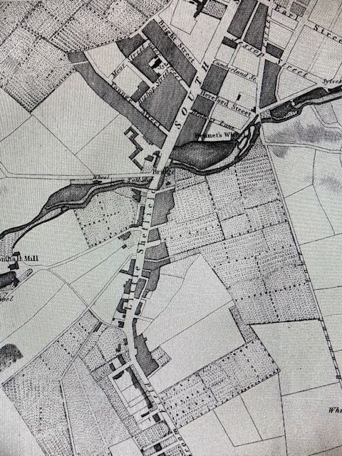
Nowadays, we can define Little Sheffield’s northern boundary as being where the Moorfoot Building stands, taking in Young Street, South Lane, St Mary’s Gate, London Road, and surrounding streets like Hermitage Street, Sheldon Street, Hill Street, John Street, and Boston Street (once called George Street), up towards its southern boundary at Highfield.
© 2021 David Poole. All Rights Reserved.
