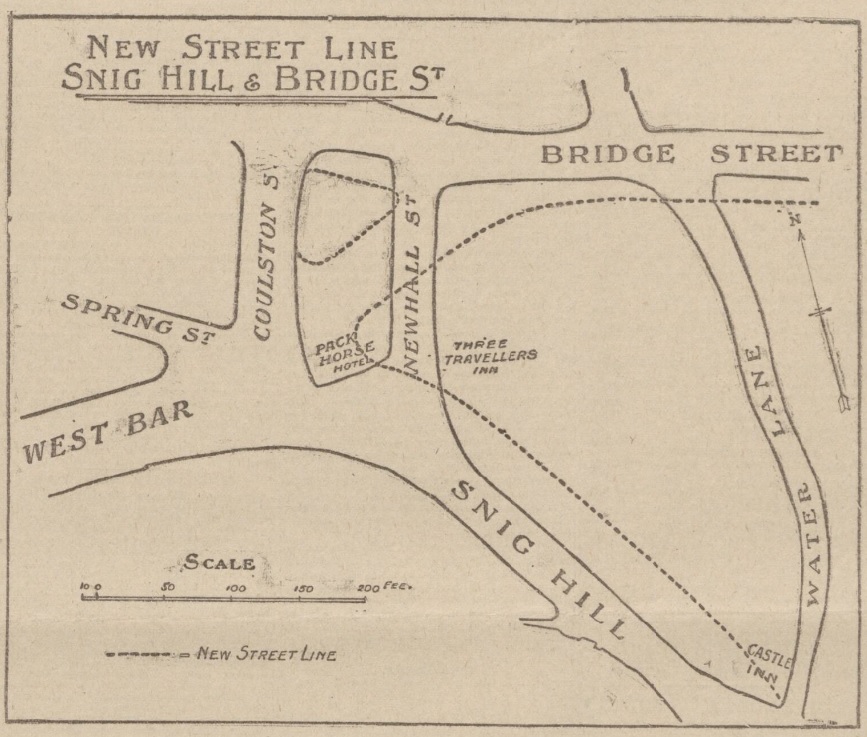
In 1900, the Improvements Committee of Sheffield Corporation paid £10,500 for 2,546 yards of land in Newhall Street. There were certain freehold premises here, including the Hollis Hospital.
The question we ask ourselves 122 years later, where was Newhall Street?
Sheffield Corporation wanted to carry out a road diversion with a straight way from Westbar to Bridge Street.
Newhall Street was at the bottom of Snig Hill and disappeared, the line of Westbar continued across land occupied by the Pack Horse Hotel (demolished), until it joined Bridge Street.
This illustration from 1902 shows the original road layout, with dotted lines indicating the new street pattern and building lines. It also shows the widening of Snig Hill.
The scheme was completed in 1903 providing a more direct route from Westbar to the Victoria Station, and in due course tram lines ran from Westbar into the Wicker. It allowed tramcars to run from Hillsborough to the Wicker and then back to Hillsborough by the Owlerton Route – another step in the completion of the city’s circular tramway system.
The loss of Newhall Street was significant because this had been the boundary between Saint Peter’s Ward and Saint Philip’s Ward, dating to 1843 when Queen Victoria granted The Charter to the Borough of Sheffield.
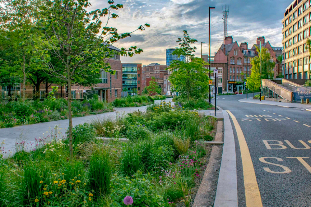
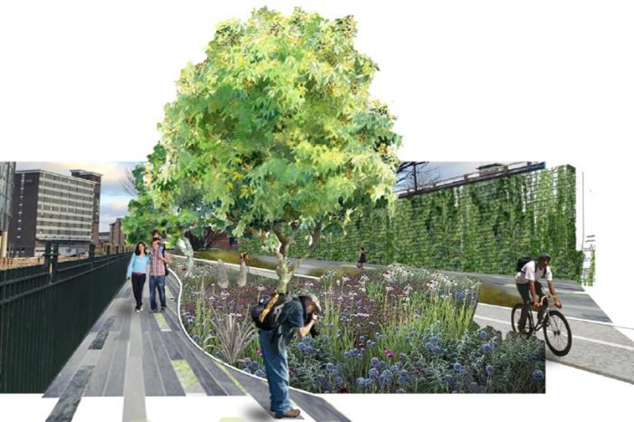
Fast forward to the present day and things are remarkably quieter, and more beautiful, thanks to Sheffield City Council’s ‘Grey-to-Green project.
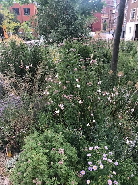
The ‘Grey to Green ’ project is a development from Sheffield City Council to transform redundant carriageway in the city centre into a network of sustainable drainage and rain gardens. The greening of West Bar has already been completed. Photograph: Nigel Dunnett.
The ‘Grey to Green ’ project is a development from Sheffield City Council to transform redundant carriageway in the city centre into a network of sustainable drainage and rain gardens. The greening of West Bar has already been completed. Photograph: Nigel Dunnett.
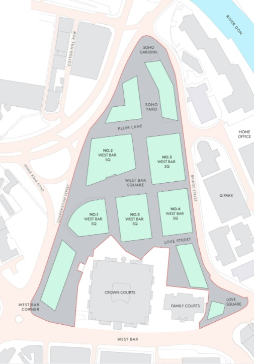
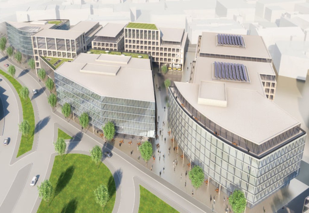
In years to come, West Bar will alter beyond recognition. The triangular area bordering West Bar, Bridge Street, and Corporation Street will be demolished. A £300m regeneration scheme will see old factories and workshops replaced with residential and business units.
According to the masterplan, West Bar Square will be a prestigious new address – a place where people will meet to do business, attracting workers and visitors, day and night. Once completed, the only recognisable buildings remaining will be the Law Courts and adjacent Family Court.
Planned area of development. Photograph: Urbo.
The development is aligned with Sheffield’s £3.6m Grey to Green scheme with wildflowers, grasses and trees already planted at West Bar. Alongside the grey to green development will be Love Square, a pop-up urban nature park designed by staff and students from the University of Sheffield’s Landscape Architecture Department.
While it is sad to see our heritage disappear, the project will go towards greening an area swallowed by the industrial revolution.
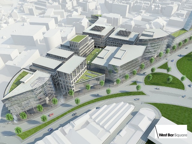
The 1.4m sq West Bar Square city centre scheme will be built next to the city’s inner relief road. Photograph: Urbo.
It will involve building 200,000 sq ft of office space, 350 build to rent homes, a multi-storey car park and quality landscaped public spaces. Photograph: Urbo.
West Bar is one of Sheffield’s oldest streets and mentioned in ancient records of the Burgery. There seems to be no explanation available as to the derivation of its name. In bygone times a ‘bar’ was a barrier of posts and chains set up to close the entrance to a town or city, and West Bar is likely to have been the northern limit of old Sheffield.
The development area was included in a survey of the manor of Sheffield in 1637 which described the site as part of Coulston (or Colston) Crofts, previously part of the demesne lands of the lord of the manor. Surviving deeds from 1622 contained wording suggesting the area was originally part of the lord’s game preserve, with all rights of hawking, hunting, fishing, and fowling reserved to the Duke of Norfolk. It was later used for both pasture and arable cultivation.
By 1637, the area had been divided into two large fields, the area on the west leased from the Duke of Norfolk by Robert Bower, and that on the east by Edward Wood. In the 17th century the area was at least partially wooded, confirmed by a description in 1837, which stated that until the late 18th century the area had been “swampy meadows and damp osier [willow] grounds.”
The West Bar area remained on the outskirts of town into the 18th century. The town’s first workhouse was built to the southwest in 1733, now survived by Workhouse Lane to the left of the Law Courts.
The street layout principally dates to the period between 1783 and 1802, although Spring Street and the streets to the south are earlier. West Bar is likely to be medieval in origin, and part of Spring Street was shown in 1736. Workhouse Lane and Paradise Street were shown in 1771.
Corporation Street cut through the estate in 1853, and was altered as part of the Inner Relief Road development in 2006.
West Bar was widened in stages during the late 19th and early 20th centuries. The construction of the Court Houses between 1993-1996 led to the truncation of Spring Street and Love Lane.
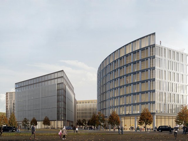
No.1 West Bar Square comprises approximately 100,000 sqft of office space, together with ground floor retail/leisure units. Photograph: Urbo.
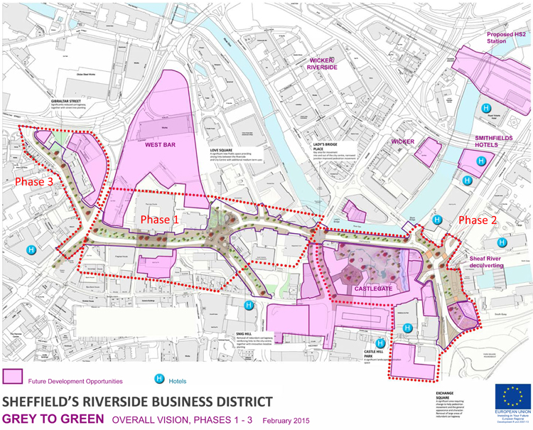
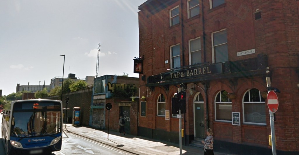
The recent post about Castlegate failed to mention that it is in the process of being part-pedestrianised, Phase 2 of Sheffield’s ‘Grey to Green’ project. Unless you visit this forgotten part of the city centre the relevance of the initiative might escape you.
It is part of an approach to transform ‘redundant’ road space into a network of public spaces, sustainable drainage and urban rain gardens, which aims to improve the setting of the Riverside Business District, Castlegate and the rest of the city centre and then on to Kelham Island and Victoria Quays, as a place to work, live and enjoy, whilst also dealing with the effects of climate change.
Phase 1 (West Bar/Bridge Street/Snig Hill) was completed in Spring 2016 and was funded by the European Regional Development Fund, Sheffield City Region Infrastructure Fund and Sheffield City Council.
The area suffered catastrophic river floods in 2007. With the completion of the Inner Relief Road in 2008, traffic was diverted away from West Bar. The opportunity was seized to replace the ‘grey’ impermeable ‘redundant’ roads into ‘green’ permeable beds, transforming the space with colourful meadow-like planting and significantly increasing surface water storage.
With advice on plant selection from the University of Sheffield Landscape Department this has created a new townscape that is different to anything done in Sheffield before. Over 40,000 bulbs, 40 new trees, 600 evergreen shrubs and 26,000 herbaceous plants were introduced to form a seasonal urban meadow.
The new road layout was designed to slow vehicle speeds and make walking and cycling more attractive. New paving, street furniture, colourful seating and five eye-catching public art ‘totems’ celebrate the local history of the West Bar area including its Victorian music halls and theatres, its lively street life, its complex relationship to the river and its legacy of industry and brewing.
Phase 2 (Castlegate to Exchange Place) is nearing completion, and Phase 3 (Gibraltar Street to Shalesmoor) will eventually transform 1.2km of ‘redundant’ road-space into an attractive new linear green public space.
The name suggests that this is one of Sheffield’s ancient roads, perhaps named after Sheffield Castle, this stronghold destroyed by Parliamentarians during the 1600s. Castlegate is the road that runs alongside the River Don between Blonk Street and the junction of Waingate and Bridge Street.
However, you might be surprised to know that Castlegate is a relatively modern road and celebrates its centenary in 2030.
The road is found on the site of the lost castle and was first suggested by Edward Mitchel Gibbs, the Sheffield architect, as part of his ambitious plans for a Viaduct Scheme connecting Great Central Station (Victoria Station) with Haymarket.
The River Don Road was the only portion of the proposal adopted by Sheffield Corporation and built to ease congestion around Blonk Street, The Wicker and Lady’s Bridge. Its construction was made easier by the council’s Castle Hill Market development built on the embankment of the castle.
Castlegate (or Castle Gate), 60 feet wide and 200 yards long, was built at a cost of £13,000 in 1930, using over 9,000 tons of material, with a one-foot layer of strong concrete laid below the asphalt.
It was divided from the River Don by an old stone wall which had to be reinforced by 14 concrete buttresses each weighing 50 tons. Over the buttresses was a solid mass of concrete stretching from the wall halfway under the road and taking the weight of the traffic.