Categories
Streets

Earl Way – while you were sleeping last night

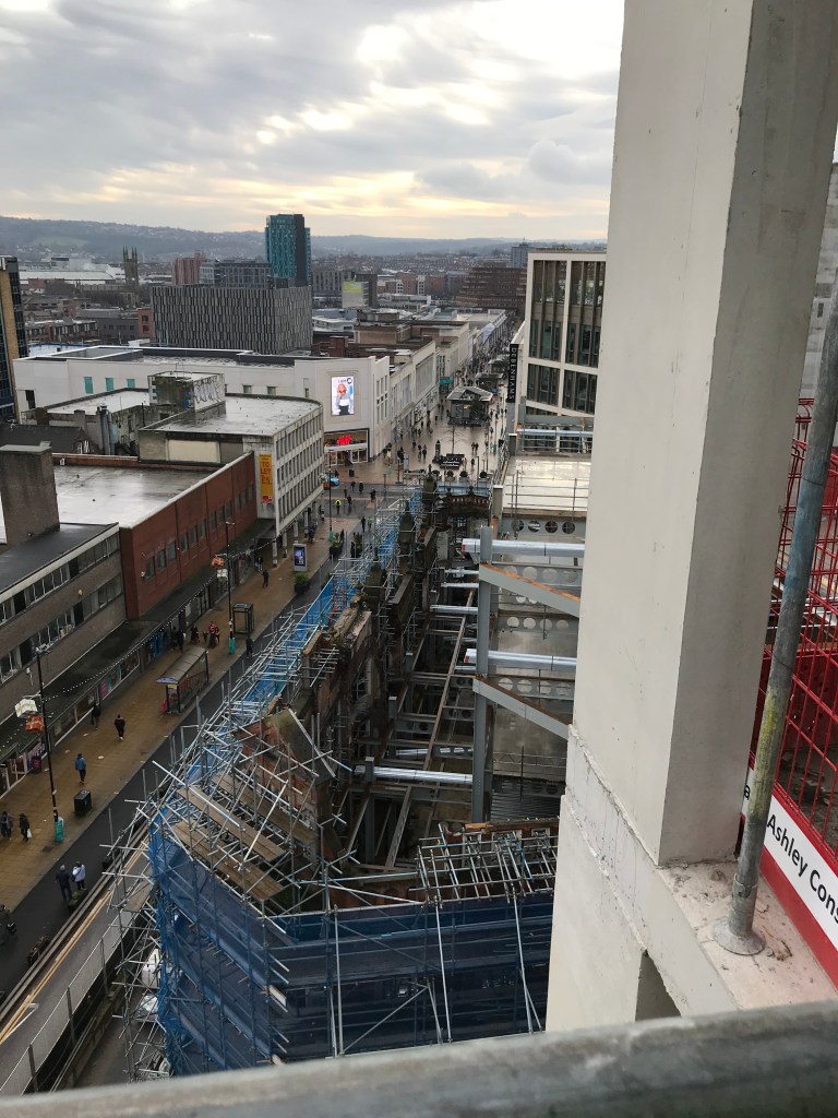
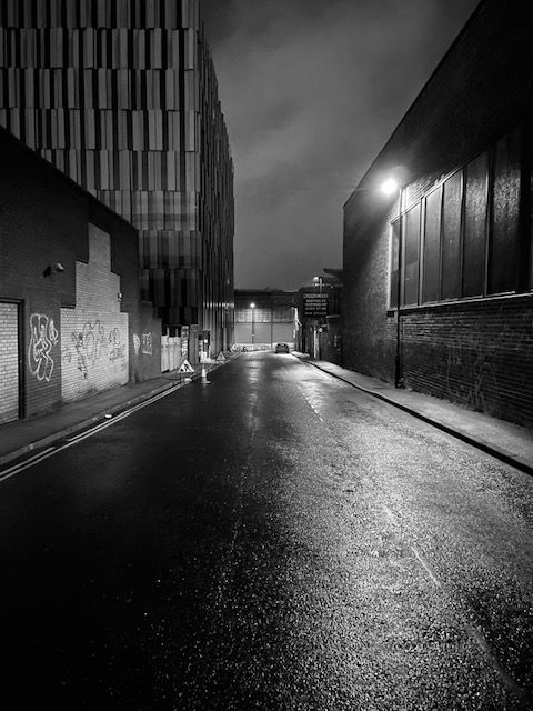
While you were sleeping last night. This is a wet and deserted Earl Way, which lies parallel between The Moor and Eyre Street.

If we go back to Norman times, and the time of Thomas de Furnival, this was thought to have been the site of a large ditch at the edge of Sheffield Deer Park, one of England’s largest deer parks, and spanning a circumference of eight miles in total.

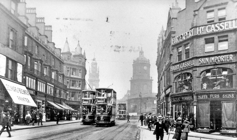
Earl Way is modern compared to most Sheffield roads. It was created in the second half of the twentieth century when this part of the city centre was redeveloped. Prior to this, there were three significant roads in the vicinity.

These were Porter Street, that ran diagonally from Hereford Street, towards Moorhead, and Porter Lane, a narrow road that linked it with Union Lane.

Union Lane once ran from Charles Street, near to the Roebuck Tavern, across Furnival Road (now Furnival Gate) and ended at Jessop Street (where the Moor Market now stands). The only surviving section of Union Lane is behind Derwent House, near The Roebuck (think deer).

In this photograph, it would have run along the left hand side where the former Plug nightclub and Kit-Kat car-park stand. Porter Street would have been to the right.

If we could go back in time, right in the centre of the picture, and in the middle of the road, would have been Porter Street School.

There were two reasons why Earl Way came into being.

Up until the 1930s, this was an area of back-to-back housing and designated for slum clearance. Then came World War Two. German bombs caused extensive damage around The Moor, Porter Street, and Eyre Street, leaving the site to be redeveloped afterwards.

Union Lane disappeared, and Earl Way was built as a link road to Earl Street (seen running across the end of the road here).

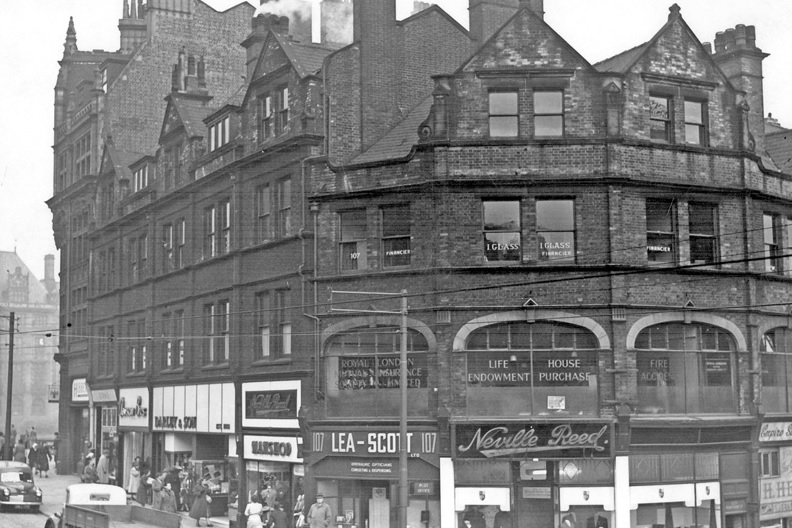
And familiar landmarks appeared too, including the Pump Tavern, later demolished to make way for the Moor Market, and Violet May, a record shop, run by a pivotal figure in the development of the music scene in Sheffield.

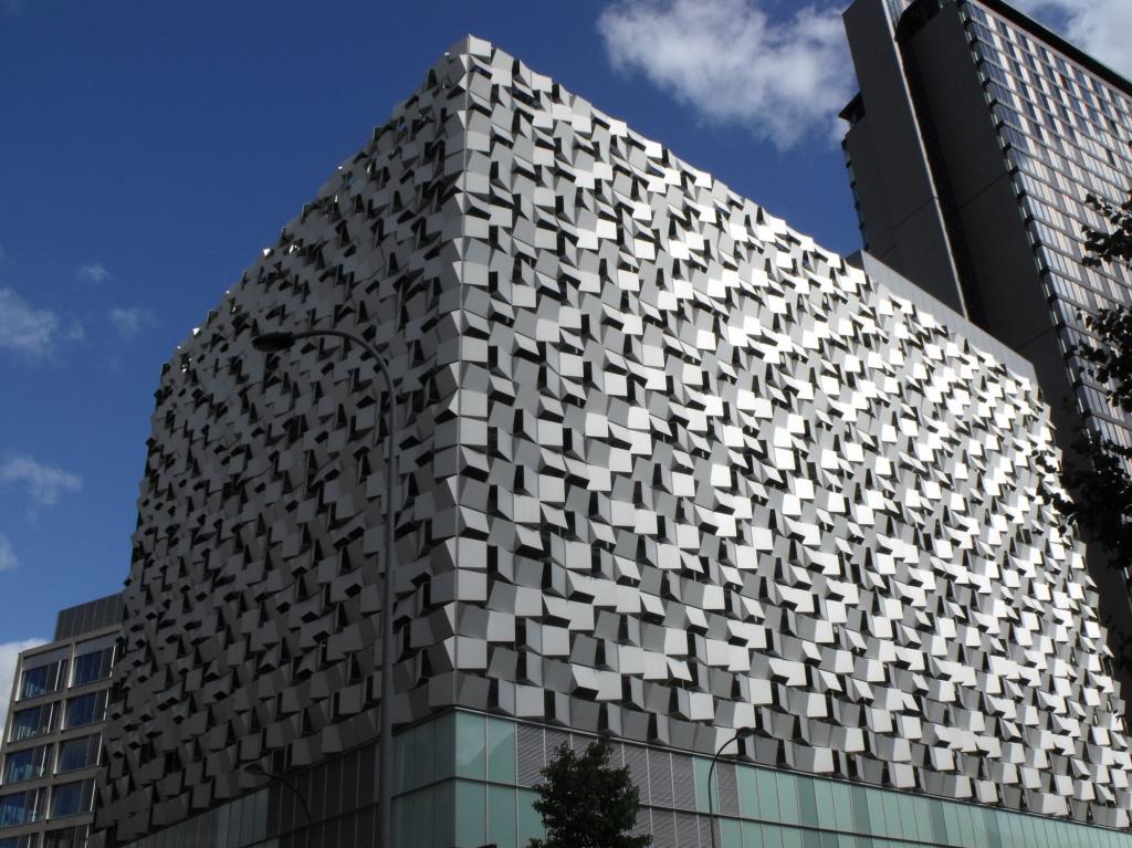
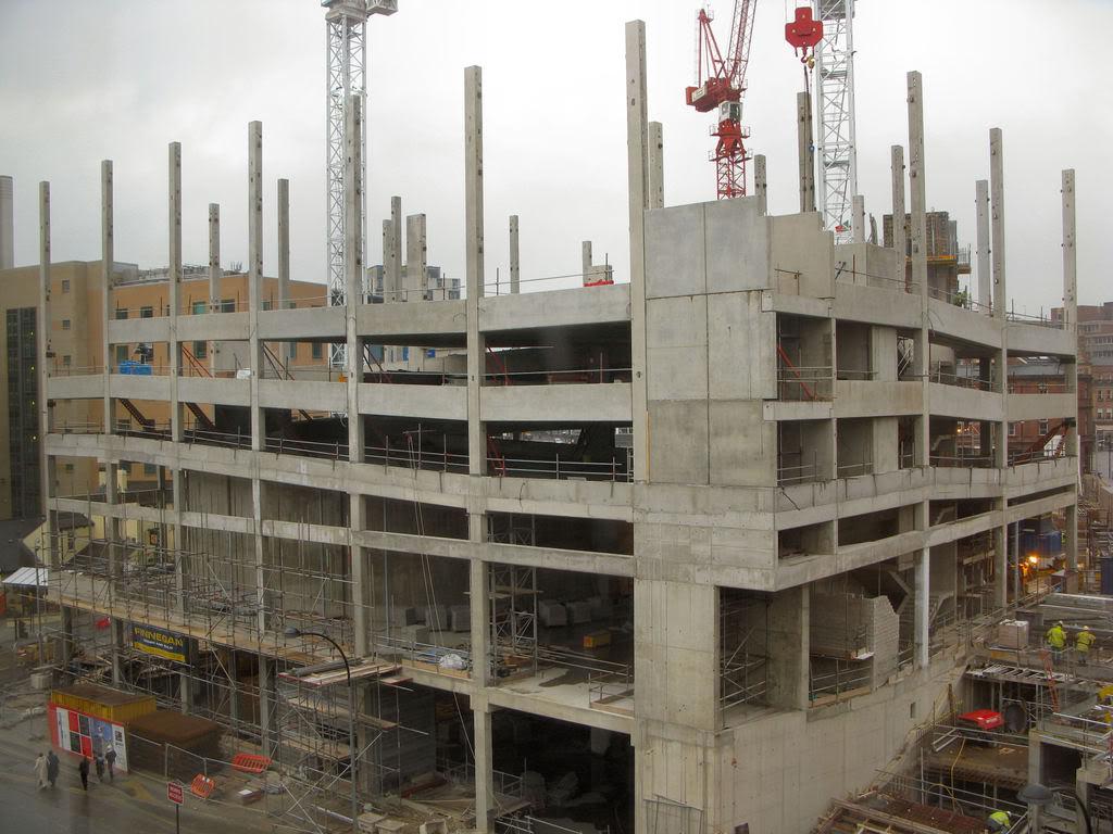
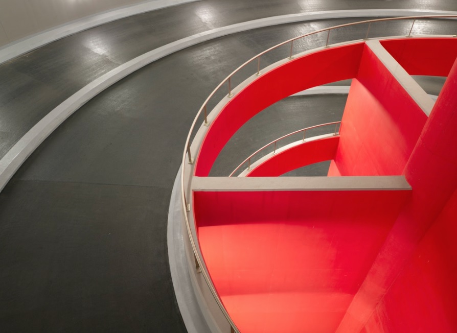
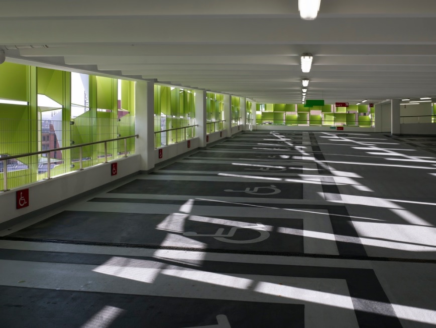
Perhaps the most dramatic modern building is the Kit-Kat car-park, designed by Broadway Malyan in 2008, and sold for £9m last month by joint owners NewRiver and BRAVO Strategies.

©2022 David Poole. All Rights Reserved.

Categories
Buildings

Charles Street Station

Charles Street Station. Image: Picture Sheffield/P. David Turton

A photograph that will confuse younger generations. Doing an excellent job at imitating the London Underground, this was Charles Street Station, pictured in 1983. This was a theme bar, but such was the authenticity, that Omnia, the online cultural site, includes the image on its London Underground pages. It was incorporated within the Isaacs Building, built by David Isaacs, a wallpaper merchant, in 1905.

Isaacs Building was an example of Edwardian entrepreneurship, the ground floor containing seven shop units with an assembly hall above, its entrance being from Charles Street. The top floor of the building contained offices and several workshops, mostly rented by enterprising tailoring businesses.

The assembly hall was once the Sheffield Trades Club and in the 1970s was converted into a nightclub, its various incarnations being Faces, Raffles, Charlie Parker’s and Freedom. For a time, the old basement was used as Charles Street Station.

Stephen Shephard busking outside Charles Street Station in 1983. Image: Picture Sheffield/Sheffield Newspapers Ltd

The bar was short-lived, and the entire building was demolished in 2020 as part of the Heart of the City redevelopment. Its replacement, modern office-space, with ground-floor retail units, is nearing completion, and is also called Isaacs Building.

©2022 David Poole. All Rights Reserved. Supporting Picture Sheffield

Categories
Buildings

Berona House: It’s business as usual for this unpretentious building

Berona House. One of the survivors of Pinstone Street’s Victorian building boom. Similar properties have had their interiors removed as part of the Heart of the City II project. Photograph: DJP/2021

We all know it, we all pass it, and we tend to overlook it. This building has stood at the corner of Pinstone Street and Charles Street for generations, and while the shops have repeatedly changed hands, we know little about it.

Berona House, or to be more precise, 95-107 Pinstone Street/31-35 Charles Street, has worked hard to hide its history.

The appearance of the building has remained unchanged since it was built, including the rounded first-floor corner windows. Photograph: Google

In 1897 the last plot of vacant land on Pinstone Street was sold by Sheffield Corporation to a private company. Prior to this, the corporation had systematically bought old properties on narrow Pinstone Lane, demolished them, and created the Pinstone Street we know now.

The land, opposite the Empire Theatre, was used to build a block of shops and dwelling houses. With brick and stone dressings and distinct first-floor corner arched windows, it was designed by Sheffield architects Holmes & Watson and constructed by George Longden and Son.

Edward Holmes (1859-1921) was in partnership, 1893-1908, with Adam Francis Watson (1856-1932), and were responsible for the City (later Lyceum) Theatre, Leopold Chambers, Norfolk Market Hall, as well as being associated with the city’s improvement scheme as valuers and advisers.

Harry Cassell, furriers, about 1910 (above) and (below) different names above the doors in the 1950s. Photographs: Picture Sheffield

The building was completed in September 1898 at a cost of £10,000 and consisted of seven shops and a restaurant – five shops on Pinstone Street, one at its corner with Charles Street, and one shop and the restaurant in Charles Street.

The list of shops that occupied ground floor premises is extensive, but one of its earliest occupants was Harry Cassell, furriers, which did a big trade in sealskin jackets. Later shops included Neville Reed, Lea-Scott opticians, Bradleys Records, and Colvin male outfitters.

It is perhaps fitting that the upper floor flats, later converted into offices, were adapted into apartments again in 2002-2003.

And maybe somebody might be able to explain the meaning behind its current name – Berona House.

Berona House, with the recent addition of a Post Office on Charles Street. Photograph: Google

© 2021 David Poole. All Rights Reserved

Categories
Buildings

The Sheffield ‘Cheesegrater’

Q-Park Charles Street, with aluminium solar shading, was designed by Allies and Morrison, also responsible for building Nunnery Square – Phase 1. Photograph: mcmedia

It is one of Sheffield’s oddest buildings, and probably one of the most photographed. Liked by many. Hated by many. The Q-Park, Charles Street, opened in 2008, and the extraordinary steel cladding merited the ‘Cheesegrater’ name.

The ten-storey car park was designed by architects Allies and Morrison, and constructed by Sheffield-based J.F. Finnegan  as part of the Heart of the City project, which also included the Peace Gardens, Winter Garden and Millennium Gallery.

The small parcel of land it sits on was once the site of the Yorkshire Grey, a public house dating to 1833, once known as the Minerva Tavern and later Bar Rio, and so there was understandable anger when it was demolished.

The frame is a precast concrete column and beam construction used to form the main car park deck. Photograph: SRC Ltd.

In its place rose this ultramodern structure with its nerve-jangling circular ramp leading to 520 parking spaces above. Car parks can be unattractive, and the precast concrete columns, walls, and floors, were hidden behind a screen of folded, anodised aluminium panels.

The external envelope, painted green on the inside, was each manufactured from a single sheet of folded aluminium, cut to an angle on two sides, and hung in four different orientations, providing natural ventilation.

“By day, a varied monochromatic pattern of light and dark is achieved over each of the elevations, with each panel giving a different light reflectance from its surface. The variety of open ends and tilted faces transform the surface as daylight fades. By night, the interior lighting bleeds between each panel and creates a non-uniform composition of light and dark across the surface.”

Photographs: Dennis Gilbert/VIEW
Photograph: mcmedia

Love it, loathe it, the car park has put Sheffield on the world map. A year after completion, it was named the ‘third coolest in the world’ by a car parking company and a design magazine. In 2019, it was voted the world’s most unusual quirky car park – beating off competition from Tokyo, Miami, and Australia, and was voted the most unusual car park in the UK in 2020.

There are even claims that Harvard University, in Cambridge, Massachusetts, built its new Science and Engineering Complex following the cheesegrater style.

Maintenance work to repair push fit friction fittings on the exterior cladding. Photograph: CAN Ltd UK

© 2021 David Poole. All Rights Reserved.

Categories
Buildings

There’s not a lot of love for the proposed C-N Tower

The CN-Tower from Norfolk Street. Image: Grantside.

A developer has responded after one of its project on the corner of Charles Street and Norfolk Street attracted 127 objections.

Grantside applied for planning permission to Sheffield City Council for a 10-storey office block, called C-N Tower, to replace two 1960s buildings.

Residents complained it would block natural light, destroy privacy and damage businesses, and Historic England is concerned about the height of the tower and its effect on existing heritage buildings.

Grantside chief executive Steve Davis said: “According to Sheffield City Council there is a ‘chronic shortage’ of high-quality, Grade ‘A’ office space in the city centre. This is hugely detrimental to Sheffield’s future economic growth both in the short term and the long-term, as potential occupiers may be forced to look elsewhere.

One of the buildings that will be demolished at the corner of Charles Street and Norfolk Street. Photograph: Sheffield Star.

The area around Norfolk Street and Pinstone Street was drastically redesigned in the late 1800s, widening and realigning Pinstone Street which involved the demolition of many buildings including some on this site.

The first building to be built on the site within the new road layout was the Three Horseshoes Hotel Public House in the 1890s. In the early 1900s buildings were built either side of the pub including the existing building St. Paul’s Chambers which originally housed the New Central Hall, cited as one of Sheffield’s first picture houses. This building also took up a section of the proposed site and became the Tivoli Cinema in 1914.

On 12th December 1940 Sheffield City Centre suffered extreme bomb damage during an intensive air raid. This included a direct strike outside the site where the Three Horseshoes Hotel and partof the Tivoli Cinema were gutted by the blast and subsequent fires.

The cinema never reopened but the Central Hall entrance signage can still be seen on the building today.

The site was eventually cleared of rubble and sat as an empty plot, used for parking during the 1950s. In the 1960s the current buildings on site were constructed and provided new offices above ground floor retail space. Over the following decades the buildings were occupied by many differing uses including BBC Radio Sheffield and a branch of The Post Office.

The C-N Tower is shown as an artist impression behind St Paul’s Building and the Prudential Assurance Building. Photograph: Grantside.

© 2021 David Poole. All Rights Reserved.

Categories
Buildings

Sheffield Hallam University

Block D will become a key anchor for Howard Street and
gateway building to the city and campus. This requires a
building facade that is both civic but restrained in its nature. (BDP)

News of a significant proposed development within Sheffield’s Cultural Industries Quarter Conservation Area.

Sheffield Hallam University has submitted a planning application for the erection of three new higher education blocks within its city campus on the existing Science Park site and adjacent surface car park. Blocks A, BC and D are planned around a new public green space provisionally named University Green. It forms a revised Phase One of SHU’s campus masterplan, initiated in 2017/18, and considers changes to the workplace because of the pandemic.

The site covers an area bordered by Paternoster Row, Howard Street, Arundel Street and Charles Street, and is alongside the Hubs complex.

The ground floor plan illustrates public entrances,
key internal spaces, range of activities and location of key
green spaces (internal yards and University Green). (BDP)

Block D will become a key civic gateway building to the city and campus. In response to this, the tallest part of the development is located at the key junction between Howard Street and Paternoster Row to symbolise a new gateway and reference to the old clock tower of the Arthur Davy & Sons building that once stood on part of the site.

The architectural expression of Block BC is three simple
masses that step down from University Green towards the
Globe Pub.
(BDP)
Block A has showcase opportunities on Charles Street and
Arundel Street where applied learning functions such as SHU
Law may be showcased. (BDP)

This area was once known as Alsop Fields where ancient hunting rights were claimed. In the late 18th century, the Duke of Norfolk set about his ambitious and grand plan to develop the neighbourhood into a fashionable residential district in response to the growing wealth of manufacture. The masterplan was prepared by James Paine. He proposed a rigid grid framework incorporating a hierarchy of streets, with main streets and a pattern of smaller ones for each urban block, serving mews to the rear of the main houses.

In the 1780s, work on the Georgian estate grid commenced to the north of the site beginning with the parallel routes of Union Street, Eyre Street and Arundel Street from the town centre, extending to Matilda Street (formerly Duke Street). However, the masterplan didn’t transpire largely because Sheffield’s inhabitants didn’t want or couldn’t afford the properties as planned.

Despite the masterplan never being wholly built, the legacy of the Duke of Norfolk is retained in many of the streets being named after his family members.

The site designated for redevelopment became a series of factories, workshops, small shops, as well as the site of the County Hotel. Much of the land was cleared during the 1980s, with the creation of Sheffield Hallam University’s Science Park (1996) in red brick by Hadfield Cawkwell Davidson. This will be swept away in the proposed development.

The Campus plan was developed around a number of
Campus plan Principles that are embedded in the design of
blocks A, BC, D and University Green. (BDP)
Illustrative photomontage view looking from Park Hill. (BDP)
Entrance to the Science Park on Howard Street. If planning permission is granted, the site will be cleared and replaced with the new development. (Wikimedia)

© 2021 David Poole. All Rights Reserved.

Categories
Other Streets

Connecting Sheffield

Our city centre may take on a new look if plans to pedestrianise large swathes of it get the go ahead. Sheffield City Council want to make foot and bicycle journeys easier and quicker, while streamlining public transport services.

The proposals include pedestrianisation to Pinstone Street and Leopold Street, linking Fargate with the Peace Gardens, as well as Charles Street between Union Street and Pinstone Street. The pedestrianisation of Surrey Street would create a traffic-free Town Hall Square.

Work would include more greenery, replicating the ‘Grey-to-Green’ scheme already seen between Castlegate and West Bar.

Bus gates would be installed in both directions on Furnival Gate, and along Arundel Gate to Norfolk Street

Rockingham Street would get a new bus hub with improvements to pavements, green planting, a pocket park, and bus stops.

The future of our city? Pedestrianisation of Pinstone Street and Charles Street connects with Heart of the City II redevelopment, due for completion in 2021. (Image: Connecting Sheffield)

Of course, there are benefits to the scheme – improved air quality, better accessibility to shops and businesses, a more attractive city centre, and public spaces that create city uniqueness.

Artist impressions paint a bright picture, but there are notes of caution.

Sheffield city centre is at a midpoint in its regeneration, with the pandemic decimating footfall, and placing even more uncertainty on retail, hospitality, and office space requirements.

The city centre is a travesty of its former self, Covid-19 exposing retailers already reeling from Meadowhall and the internet. And, after restrictions are eventually lifted, how many pubs, bars, and restaurants, will have survived?   

Half-hearted attempts to open cycle lanes at the heart of the city, further reducing traffic flow, have met with lukewarm response. With respects to cyclists, our seven hills make four wheels the favoured choice in and out of the city.

The prospect of a Town Hall Square, with pedestrian access and cycle routes linking Fargate, Leopold Street, Surrey Street, and the Peace Gardens. (Image: Connecting Sheffield).

The key to any redevelopment must take into consideration transport links.

Cars are already deterred from entering due to over-complicated traffic flow and the extortionate cost of parking. Our buses remain empty, not least because nobody knows where they go, or where to catch them anymore. Our elderly citizens must walk a distance to catch a bus, and the question remains whether they will bother anymore?

We must tread carefully, mindful that change must happen if our city centre is to be revitalised.

Any changes must take place before 2023 to qualify for a Government grant, managed by Sheffield City Region, and must be subject of public consultation.  

An overview of the ‘Connecting Sheffield’ proposal, providing a green space around the city centre. (Image: Connecting Sheffield)

Connecting Sheffield

© 2020 David Poole. All Rights Reserved.

Categories
Buildings

The new Isaacs Building takes shape

Scaffolding and new steel work support retained Victorian fronts on Pinstone Street. (Image: Heart of the City II)

A photograph that tells a story. The remains of the Victorian facade at the lower end of Pinstone Street in Sheffield city centre. Everything behind has been demolished, and the famous old fronts preserved for posterity.

Block C of the Heart of the City II masterplan is located between Pinstone Street, Cambridge Street and Charles Street.

It incorporates two historic building blocks which form the southern end of the Pinstone streetscape.

The combined façade and its dramatic roofscape is an excellent example of Sheffield brick and terracotta architecture. It occupies a prominent position and is visible from the Peace Gardens through to The Moor.

Block C will be home to 39,000 sq ft of premium Grade A office space, serving 450 employees, plus six premium retail units comprising over 8,000 sq ft.

It will be known as the Isaacs Building, named after Edwardian-era paper-hangings merchant David Isaac, and is scheduled to be completed in 2021.

Categories
Buildings

Grosvenor House

Making use of the rooftop terrace. Not bad at all. Grosvenor House, the name chosen by HSBC employees, and paying homage to the hotel that stood here before. The main office entrance is located on the corner of Wellington Street and Cambridge Street, and another entrance faces onto a new area of public realm at Charter Square. The building will also include retail space and shop fronts will be primarily located on Cambridge Street and also the important corner where Pinstone Street meets Furnival Gate. HSBC employees in Sheffield are being relocated from their current office space at Griffin House after the banking giant signed as the anchor tenant on a 15-year lease, committing them to Sheffield city centre.

Categories
Buildings

Heart of the City II

New images have been released of Sheffield’s Heart of the City II scheme. The £500million development is being built on land between Pinstone Street. Barker’s Pool and The Moor, including shops, two four or five-star hotels, offices, apartments leisure venues and a high-end food hall, all set around tree-lined streets and public spaces overlooked by rooftop bars and cafes.

The CGI images show the Victorian facades on Pinstone Street being retained. They also show the Five Ways area – the name being given to the pedestrianised interchange where Cross Burgess Street, Charles Street, Cambridge Street and Wellington Street meet.

There is also work to restore Laycock House, a late Victorian building that survives almost completely intact, as part of the Block B element of the scheme. Known as Athol House, it will provide space for restaurants or cafes on the ground floor, while the floors above will include office space.

Block C will be known as Isaacs House after Victorian-era paper-hangings merchant David Isaacs. Behind the Pinstone Street frontage the re-imagined building will contain workspaces, prime retail and leisure space.

Heart of the City II is one of Sheffield’s key economic projects. Backed by Sheffield City Council, with Queensberry as its Strategic Development Partner, it is not just a retail scheme, but mixed-use development.

The scheme builds on the hugely successful original Heart of the City project that kick started the regeneration of Sheffield city centre at the start of the Millennium.