Categories
Streets

Is there anything to discover underneath the streets beside the City Hall?

Sheffield City Hall, Barker’s Pool, with Holly Street (left), and Balm Green (right). Image: GoogleEarth

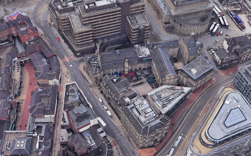
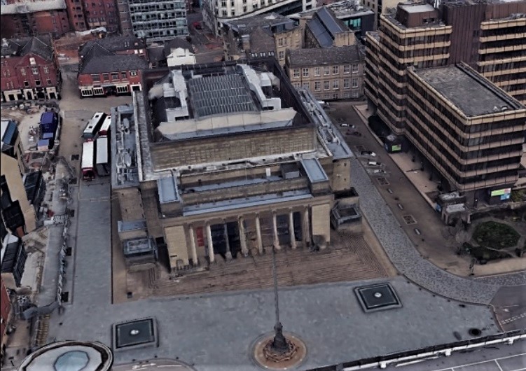
I have an intriguing question. If we were to dig beneath the roads flanking the City Hall, what would we find?

Holly Street and Balm Green, both 60ft wide, were created in 1932 to service the newly constructed building.

“The importance of a big space is emphasised when it is realised that between 3,000 and 4,000 people will frequently leave the City Hall within a few minutes and many of them will have motor-cars,” said M. J. Hadfield, the City Engineer, at the time.

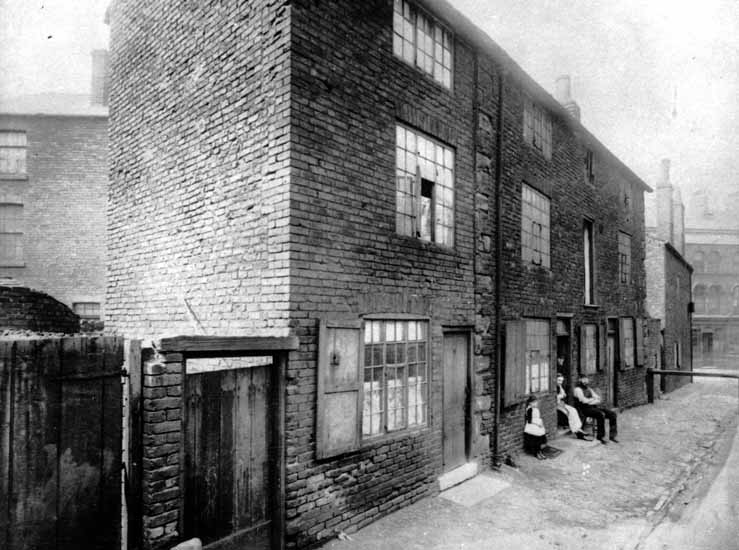
It turned out to be a massive undertaking because the roads were built over old cellars and three deep wells and required a bed of 12 inch concrete with double reinforcements, triangulated to provide the greatest possible strength at the least expense. Masses of iron rods were intertwined in the form of triangles, allowing the roads to carry weights more than 100 tons.

The cellars had belonged to shops between Pool Square and Holly Street and had been erected well over a hundred years before. In the first instance they were private dwellings, but in the course of time were reconstructed and remodelled as shops and demolished to make way for the City Hall.

What undiscovered treasures lay beneath these roads?

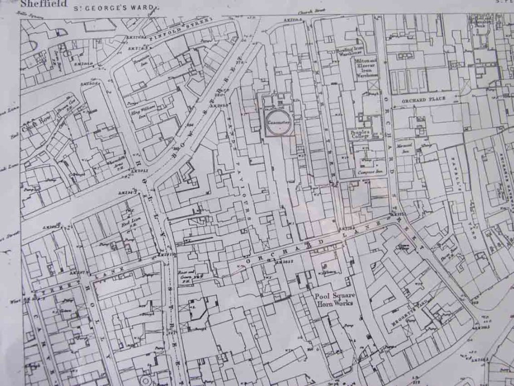
In the Burgery of 1609 Holly Street is referred to as Blynde Lane, and in 1700 is called Blind Lane or Hollin Lane, while the records of 1823 show it as Hollin Street. The corruption of Hollin Street to Holly Street is simple because ‘hollin’ or ‘hollen’ was an ancient name for holly.

In Fairbank’s survey, what is now Barker’s Pool appears as Balm Green, while the lane now known as Balm Green was called Flint Well. In Taylor’s survey of 1832, Balm Green had been renamed Barker’s Pool, while Flint Well was known as Flint Well Lane. With the building of the City Hall, Flint Well Lane became Balm Green.

The origin of Balm Green is one that has puzzled historians, but there is a likely explanation.

Joseph Woolhouse wrote in 1832, that a Mr Barker was living at Balm House, a large farmhouse supposed to be situated in Coal Pit Lane (now Cambridge Street). Behind the house were orchards where now Back Fields is. It is possible that Balm Green was the herb garden attached to the orchards.

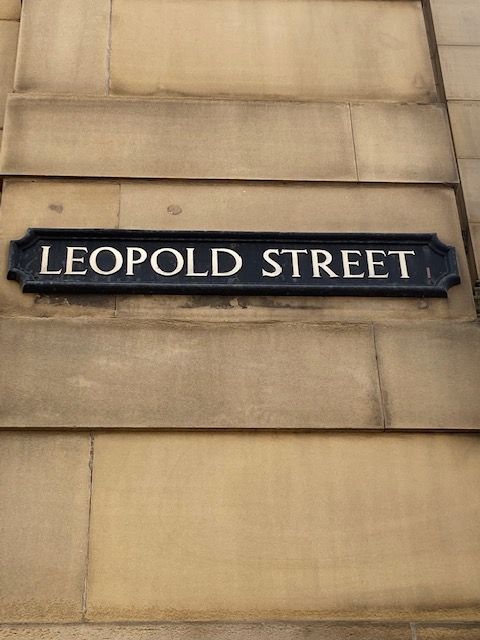
But we should also consider that Orchard Street, between Church Street and Leopold Street, was once the site of an extensive fruit garden known as Brelsforth’s Orchard, and Balm Green might have been the herb garden attached to this property instead.

A less likely theory suggests that the open space between the former John Lewis department store and the City Hall was once called Le Baine, with an early reference in a deed of 1333. Because the area was rich in springs and wells, it has been suggested that Le Baine evolved from the Latin word ‘balneum’, a warm bath, or a place for swimming, and eventually into ‘balm’.

Mr Barker established our first waterworks at Balm Green in 1434. The area subsequently became Barker’s Pool and two centuries later, it was cleaned and repaired by a public benefactor, Robert Rollinson, and for upwards of three centuries was in daily use. The pool in its latter days became defiled; the rubbish of the town, and dead animals, were thrown in, and it was subsequently filled up in 1793.

©2022 David Poole. All Rights Reserved.

Categories
Streets

Sands Paviours – a long forgotten street

West side of Sands Paviours (ran from Orchard Lane to Bow Street), pre 1890, demolished to make way for the Central Schools, Science School. Image: Picture Sheffield

Today, a look at a street in Sheffield city centre that was consigned to history long ago.

In 1874, a plan was produced by Sheffield architects, Innocent and Brown, for the laying out of Leopold Street, and the realignment of Church Street and Bow Street (now the bottom-end of West Street).

About this time, land between Orchard Lane, Bow Street, Orchard Street and Balm Green was covered by old houses in two streets, Smith Street and Sands Paviours.

The site was bought by the Sheffield School Board for building the Central Schools and offices. At the same time, Mark Firth founded Firth College, later part of the University of Sheffield, and this was opened by Prince Leopold in 1879.

The removal of old property between Bow Street and Orchard Lane caused the obliteration of the marvellously named Sands Paviours.

But what had once been a pathway across rural land had become a street of slum housing, workshops, shops, and a public house called the Norfolk Arms. And murder and crime were evident on the street.

According to John Daniel Leader, this little court of houses may have derived its name from Samuel Sands, who flourished in the reign of Queen Ann.

By an indenture dated 25 September 1708, Samuel Sands, a Sheffield cutler, conveyed to George Hawke of Leavygreave, yeoman, for the sum of £100, all that messuage, near the Townhead Cross with a smithy, barn, orchard, and garden, lately in the possession of John Hobson; also, a cottage adjoining, lately in the possession of Mary Wilson, to hold the same for ever of the chief Lord or Lords of the fee. The vendor signed his name ‘Samwell Sandes.”

However, there was another suggestion for it being named so.

In other towns there were streets called Sans Paviours (without paving stones), and it might be that because Sandes’ house was here, that he saw the name Sans Paviours elsewhere, and thought it appropriate for his own property.

The mystery was cleared up when the land was bought by the School Board, and the old deeds showed that it had been in the family called Sandes from 1657 to 1727, and that early mention was also made to Sands Croft and Sands Orchard.

Like many old street names that were adapted over the years, Sands Paviours was also referred to as Saint Pavers.

Remember this the next time you relax in Leopold Square. There is history beneath your feet.

Sands Paviors once ran from Orchard Lane to Bow Street (now the bottom part of West Street). Image: Google

© 2022 David Poole. All Rights Reserved.

Categories
Buildings

Wine bar plan for old West Street building

We wait with anticipation as to what happens to this redundant building at 43-45 West Street, at its corner with Holly Street. It was built in 1914, the year the First World War started, as shown by a carving in the Ashlar stone, and planning permission has been granted to turn it into a wine bar.

The property has most recently been used as a men’s’ hairdressers and salon and is now vacant.

The good news is that the exterior of the building will be sympathetically restored with the removal of ugly brick infills and floor-to-ceiling glazing at first-floor level.

The interior is remarkably narrow, with the back of the building mostly taken by the derelict former Old Red Lion public house.

Categories
Buildings

St James House

A familiar sight on the city centre skyline. St James House is one of Sheffield’s oldest office blocks, built in the 1960s, and still serving the same purpose today. (DJP/2021)

St James House, on Vicar Lane, may be an unassuming 11-storey office block. However, we shouldn’t forget that this 1960s construction plays an important part in Sheffield’s history.

The miners’ strike of 1984–85 turned out to be one of the bitterest fights in British history. The industrial action was to shut down the British coal industry in an attempt to prevent colliery closures. It was led by Arthur Scargill of the National Union of Mineworkers (NUM) against the National Coal Board (NCB), a government agency. Opposition to the strike was led by Prime Minister, Margaret Thatcher, who wanted to reduce the power of the trade unions.

Striking miners lobbying Miners Union leaders (who were meeting to decide strategy) outside St James House in March 1984) (Picture Sheffield)

Long-based in London, Scargill decided to move his headquarters to Sheffield ahead of the strike, and in 1983 chose St James House as temporary accommodation until custom-built offices were built on Holly Street. It had been completely refurbished, and the NUM occupied floors from eight to eleven, and half of the seventh floor for storage. Ironically, these floors had previously been used by the NCB pensions and insurance department.

In ‘Britain’s Civil War over Coal: An Insider’s View’ by David Feickert, he says that Arthur Scargill designed the office layout himself and his managerial views were firmly stamped on the design. “It was an office design straight out of the 1950s, but Arthur defended it rigorously.”

It was here that Scargill fought to the bitter end, and created the biggest news stories of the day. (I don’t need repeat what happened, neither do I need to report on the rights or wrongs. We’re looking at a building, after all).

The NUM vacated St James House in 1988, moving to brand-new offices on Holly Street (designed by Malcolm Lister in 1983, and now home to Grant Thornton, Pitcher & Piano, and Turtle Bay), and stayed four years before relocating to Barnsley.

St James House, before the time of the NUM, photographed in October 1981. (PIcture Sheffield)

© 2021 David Poole. All Rights Reserved.

Categories
Buildings Streets

Leopold Street

Work in progress. The pedestrianisation of Leopold Street (above), Pinstone Street, and Surrey Street, will create a traffic-free Town Hall Square. (DJP/2021)

Our city centre is at a crossroads. The city is in flux and a street that highlights it most is Leopold Street. Buses no longer run along here, and all traffic is halted mid-way. Sheffield is going car-free, and with it our streets become soulless. Nothing is sadder than a street about to undergo pedestrianisation. It is blocked with traffic cones and concrete barriers and unsure what it wants to be.

As far as Sheffield streets go, Leopold Street is relatively new, a pet-project for town planners in 1873.  Back then, access to Fargate and Pinstone Street was via Church Street, along awkwardly narrow Orchard Street, to its junction with Orchard Lane, and dog-legged towards what is now the top of Fargate.

Its making was the result of Sheffield Corporation’s three-street development scheme – the creation of Surrey Street, Fargate improvements, and the construction of ‘modern-day’ Pinstone Street. A new road was needed to link these streets with Bow Street (the road that became the bottom of West Street) and a link between old Sheffield Moor and Shalesmoor.

A long-standing road, South Street, was swept away, the land around it cleared, and the large sloping site bounded by the proposed new road, Orchard Lane, Holly Street and Bow Street (West Street) earmarked for educational purposes. It became the site of Firth College (1879), School Board offices and the Central School (both 1880). Of course, we now know these buildings as the Leopold Hotel and Leopold Square

By May 1880, half its length had been completed, 60-feet wide from Bow Street to Fargate, paved in wooden blocks, and converted to macadam in 1883.

Aerial view of Leopold Street. The Leopold Hotel and Leopold Square are centre. Before 1880, the main route between Church Street and Fargate was along narrow Orchard Street, to the left, which curved at its junction with Orchard Lane (where the mini-roundabout is today). The top-end of Orchard Street (near to Fargate) was absorbed into Leopold Street. (Google)

The Watch Committee recommended that the new street be named after Prince Leopold, Duke of Albany (1853-1884), eighth and youngest son of Queen Victoria, who had opened Firth College in October 1879.

The addition of the Sheffield Medical Institution on the other side of the road in 1888 prompted one expert to say that Leopold Street would become a “street of institutions.”

It never became a street of learning. Firth College and the Medical Institution were the foundation stones for the University of Sheffield and moved away. By the late 1970s, the old education buildings were in decline, mostly unoccupied, but spared the fate that befell the nearby Assay Office and Grand Hotel, both demolished, and replaced with office blocks.

A street sign on the wall of what was once Firth College, at its junction with West Street, and now part of the Leopold Hotel. (DJP/2021)

© 2021 David Poole. All Rights Reserved.

Categories
Buildings

Old Red Lion

One Saturday night, in September 1926, Alfred Henwood finished his pint at the bar of the Old Red Lion on Holly Street and walked out. He returned just after time and said he had left his beer on the counter.

The landlord, Charles Foreman, told Henwood that he had seen him drink his beer. Not satisfied, Henwood picked up another jar of beer, which was not his, and refused to put it down. He told the licensee that if he could not have a pint, he would smash all the glasses. Thereupon he spread his arms around the glasses – five-and-a-half dozen – and every one was smashed.

He claimed in court that it was an accident but was fined £3.

Just another story in the life of an old Sheffield pub.

The Old Red Lion opened in 1822, life and soul for the surrounding houses and small industries. Slum-like flats used to be attached to the property, long demolished and the land vacant ever since.

The Old Red Lion, a William Stones establishment, moved with the times. The locals moved and industry declined but when the City Hall opened in 1934 it became a favourite watering hole.

In the 1980s it was remodelled – knocked through into the property behind – the former works of J.W. Northend, printers, which became a bar known as Barkers (becoming Edwards, later Reflex and now the Slug and Lettuce).

But times are hard now for the Red Lion. A separate property again, it’s nearly ten years since it closed and has been boarded-up ever since. The City Hall clientele prefer the Wetherspoon options at the front, and the Red Lion is stuck at the arse-end of West Street.