Happy Yorkshire Day. A celebration of the United Kingdom’s largest county.
Named after the old county town of York, we are familiar with its sub-division into North, West, South Yorkshire (the best of the lot), and Humberside.
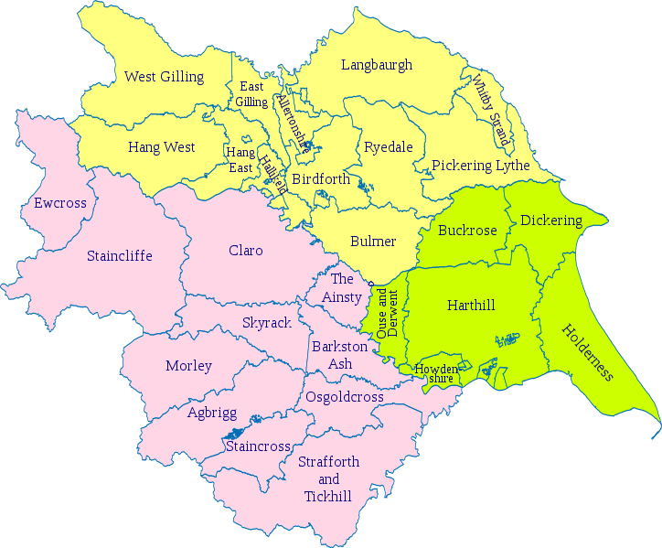
But these are modern creations, and until 1974, the county was split into three ‘Ridings,’ derived from the Old Norse Þriding or Þriðing, meaning a “thirding”.
Yorkshire was divided into three ridings and surrounded the city of York, their boundaries meeting at the walls of the city: thus, York within the walls was the only part of Yorkshire outside any of the ridings.
East Riding, was the smallest and least hilly of the three, much of it in the plains extending from the north bank of the Humber and containing the seaport city of Kingston upon Hull.
The North Riding, extending from the Pennines to the North Sea, was the most rural but still contained Middlesbrough on industrial Teesside.
The West Riding, the largest and most urbanised as the southern part, contained the great industrial cities of Yorkshire, the largest being Sheffield and Leeds, though in its north it encompassed some of the finest of the Yorkshire Dales.
And each riding was divided into wapentakes, the Danelaw equivalent of an Anglo-Saxon Hundred in most other counties. The word derived from an assembly or meeting place, usually at cross-roads or near a river, where literally one’s presence or a vote was taken by a show of weapons.
And Sheffield was in the southern most wapentake of Strafforth and Tickhill, the original meeting place unknown, but may have been the future site of Conisbrough Castle, near Doncaster.
And to add further confusion, there are portions of the great county which retain, from old feudal times, names unrecognised by the geographer, but well known and adopted by Yorkshiremen themselves. You may look in vain on a map for Cleveland, Richmondshire, Hallamshire, Craven, or Holderness, but you will hear of them spoken in each area.
Hallamshire, a large manor at the time of the Conquest was the southern most part of the West Riding, including Sheffield.
South Yorkshire was created on 1 April 1974 because of the Local Government Act 1972. It was created from 32 local government districts of the West Riding of Yorkshire (the administrative county and four independent county boroughs), with small areas from Derbyshire and Nottinghamshire. South Yorkshire County Council was abolished in 1986 and its four metropolitan boroughs (Sheffield, Rotherham, Barnsley, and Doncaster) effectively becoming unitary authorities, although the metropolitan county continues to exist in law.
And while we are left with North, West, and South Yorkshire, Humberside reverted to its original name of the East Riding of Yorkshire in 1996.
If you’ve stuck with it so far, I’ll confuse you further by throwing in the South Yorkshire Mayoral Combined Authority (formerly Sheffield City Region), led by Oliver Coppard, Mayor of South Yorkshire.
He has powers over transport, economic development and regeneration, and includes the metropolitan county of South Yorkshire as full members, with North East Derbyshire, Derbyshire Dales, Bassetlaw, Chesterfield and Bolsover, non-metropolitan Districts, as non-constituent members.
Be proud!